
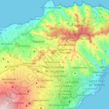
San Cristóbal de La Laguna topographic map
Interactive map
Click on the map to display elevation.
About this map
Name: San Cristóbal de La Laguna topographic map, elevation, terrain.
Average elevation: 408 m
Minimum elevation: -1 m
Maximum elevation: 1,267 m
Owing to its northerly aspect that captures moisture from the prevailing northeasterly winds, San Cristóbal de La Laguna has a Mediterranean climate (Köppen: Csb) that contrasts with the arid climate of other cities on the Canary Islands, with three to five times more rainfall than on the southern slopes, around ten percent less sunshine, and about ten percent higher humidity throughout the year. In spite of its elevation, the maritime and subtropical influences keep the temperature above frost at all times.
Other topographic maps
Click on a map to view its topography, its elevation and its terrain.
Menorca
Spain > Balearic Islands > Es Migjorn Gran
Menorca, es Migjorn Gran, Menorca, Balearic Islands, 07749, Spain
Average elevation: 9 m
les Llosses
les Llosses, Ripollès, Girona, Catalonia, 17512, Spain
Average elevation: 914 m
Grandal
Spain > Castile and León > Hontoria de la Cantera
Grandal, Hontoria de la Cantera, Burgos, Castile and León, Spain
Average elevation: 978 m
Granada
Spain > Andalusia > Comarca de la Vega de Granada
Granada, Comarca de la Vega de Granada, Granada, Andalusia, Spain
Average elevation: 829 m
Andorra
Spain > Aragon > Andorra-Sierra de Arcos
Andorra, Andorra-Sierra de Arcos, Teruel, Aragon, 44500, Spain
Average elevation: 626 m
Málaga
Spain > Andalusia > Málaga-Costa del Sol
Málaga, Málaga-Costa del Sol, Malaga, Andalusia, Spain
Average elevation: 276 m
Alicante
Alicante, l'Alacantí, Alacant / Alicante, Valencian Community, Spain
Average elevation: 143 m
Barcelona
Spain > Catalonia > Barcelonès
Barcelona, Barcelonès, Barcelona, Catalonia, 08001, Spain
Average elevation: 65 m
Meitufe do Medio
Spain > Galicia > Ordes > Ordes
Meitufe do Medio, Leira, Ordes, A Coruña, Galicia, Spain
Average elevation: 383 m
Fuente del Donante de sangre
Spain > Bajo Guadalentín > Aledo > Las Canales
Fuente del Donante de sangre, Las Canales, Aledo, Bajo Guadalentín, Spain
Average elevation: 578 m
Oza-Cesuras
Oza-Cesuras, Betanzos, A Coruña, Galicia, Spain
Average elevation: 305 m
Cocentaina
Cocentaina, el Comtat, Alacant / Alicante, Valencian Community, 03820, Spain
Average elevation: 609 m
Villafranca del Bierzo
Spain > Castile and León > El Bierzo
Villafranca del Bierzo, El Bierzo, León, Castile and León, Spain
Average elevation: 910 m
Villar de la Encina
Villar de la Encina, Cuenca, Castile-La Mancha, 16648, Spain
Average elevation: 836 m
Alcoleja
Alcoleja, el Comtat, Alacant / Alicante, Valencian Community, 03814, Spain
Average elevation: 929 m
Villanueva de Alcorón
Villanueva de Alcorón, Guadalajara, Castile-La Mancha, 19460, Spain
Average elevation: 1,252 m
San Sadurniño
San Sadurniño, Ferrol, A Coruña, Galicia, Spain
Average elevation: 203 m
Antromero
Spain > Gozón > Luanco / Lluanco
Antromero, Luanco / Lluanco, Gozón, 33430, Spain
Average elevation: 26 m
Erratzu
Spain > Navarre > Baztan-Bidasoa > Baztan
Erratzu, Baztan, Baztan-Bidasoa, Navarre, 31714, Spain
Average elevation: 432 m
Alcalá de Guadaíra
Alcalá de Guadaíra, Sevilla, Andalusia, Spain
Average elevation: 53 m
Benasque/Benás
Spain > Aragon > La Ribagorza
Benasque/Benás, La Ribagorza, Huesca, Aragon, Spain
Average elevation: 2,140 m
Hondón de los Frailes
Hondón de los Frailes, el Vinalopó Mitjà / El Vinalopó Medio, Alacant / Alicante, Valencian Community, 03689, Spain
Average elevation: 466 m
Planes
Planes, el Comtat, Alacant / Alicante, Valencian Community, Spain
Average elevation: 523 m
Casas de Ves
Casas de Ves, Albacete, Castile-La Mancha, Spain
Average elevation: 685 m
Iznate
Spain > Andalusia > La Axarquía
Iznate, La Axarquía, Malaga, Andalusia, 29792, Spain
Average elevation: 251 m
Ronda
Spain > Andalusia > Serranía de Ronda
Ronda, Serranía de Ronda, Malaga, Andalusia, Spain
Average elevation: 801 m