
Nikko topographic map
Click on the map to display elevation.
About this map
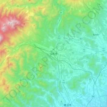
Name: Nikko topographic map, elevation, terrain.
Location: Nikko, Nikkō, Tochigi Prefecture, 321-1271, Japan (36.56146 139.53342 36.88146 139.85342)
Average elevation: 581 m
Minimum elevation: 116 m
Maximum elevation: 2,442 m
Other topographic maps
Click on a map to view its topography, its elevation and its terrain.
Hokkaido
Japan's coldest region, Hokkaido has relatively cool summers and icy/snowy winters. Most of the island falls in the humid continental climate zone with Köppen climate classification Dfb (hemiboreal) in most areas but Dfa (hot summer humid continental) in some inland lowlands. The average August temperature…
Average elevation: 98 m
Okinawa Island
The Motobu Peninsula in the north has limestone layers and karst development. In the center and south is mainly a Ryukyu limestone layer and mudstone. The topography is flat, there are few hills over 100 m (328 ft) with very few rivers. The subtropical rains accelerate erosion so there are many drainages and…
Average elevation: 14 m
Kanagawa Prefecture
Topographically, the prefecture consists of three distinct areas. The mountainous western region features the Tanzawa Mountain Range and the volcano Mount Hakone. The hilly eastern region is characterized by the Tama Hills and Miura Peninsula. The central region, which surrounds the Tama Hills and Miura…
Average elevation: 170 m
Tsushima Island
Tsushima is the closest Japanese territory to the Korean Peninsula, lying approximately 50 km from Busan. On a clear day, the hills and mountains of the Korean peninsula are visible from the higher elevations on the two northern mountains. The nearest Japanese port, Iki, situated on Iki Island within the…
Average elevation: 16 m
Tanegashima Island
The island is of volcanic origin; however, unlike neighboring Yakushima, it presents a flat appearance, with its highest elevation at only 282 metres (925 ft) above sea level. The island has a length of 57 kilometres (31 nmi) and a width ranging from 5 kilometres (2.7 nmi) to 10 kilometres (5.4 nmi). The…
Average elevation: 14 m
Kuchinoerabu Island
Japan > Kumage County > Yakushima
Kuchinoerabu-jima is located 130 kilometres (70 nmi) south of Kagoshima. The island is of volcanic origin, and has an area of approximately 38 square kilometres (15 sq mi) with a length of 12 kilometres (7.5 mi) and width of 5 kilometres (3.1 mi). The highest elevations on the island are Furudake (古岳),…
Average elevation: 47 m
Ota
Ōta is located in the extreme southeastern portion of Gunma Prefecture in the northern Kantō Plains, bordered by Tochigi Prefecture to the east and Saitama Prefecture to the south. The city is located 80 kilometres (50 mi) northwest of Tokyo between the Tone and Watarase rivers. It is located about 80…
Average elevation: 61 m
Takeshima
Japan > Kagoshima County > Mishima
Takeshima is one of the Ōsumi islands, and is located 94 kilometres (51 nmi) south of Kagoshima. The island is of volcanic origin, being adjacent to the northern rim of the Kikai Caldera and predating the Akahoya eruption. It has an area of approximately 4.2 square kilometres (1.6 sq mi). The highest…
Average elevation: 14 m
Seki
Seki is located in central Gifu Prefecture at the northern tip of the Nōbi Plain, approximately 40 kilometers north of Nagoya. Due to various municipal mergers, the city has a "U" shape, almost enclosing the city of Mino. Also as a result of the merger, the population center of population in Japan now is…
Average elevation: 372 m
Gokase
Gokase is located in the northwest Miyazaki Prefecture, in the center of the Kyushu Mountains, and borders Kumamoto Prefecture from the northern part of the town to the northwest, west, and southwest. The area is generally high in altitude, with even the hilly area in the north, the center of the town, being…
Average elevation: 766 m
Iki Island
Iki Island is slightly oval in shape, and measures approximately 17 kilometres (11 mi) from north-south and 14 kilometres (8.7 mi) from east-west. The highest elevation is Takenotsuji (岳ノ辻), a weakly curved peak with a highest elevation at 212.9 metres (698 ft) above sea level. The average height of the…
Average elevation: 21 m
Kawakami
Kawakami (川上村, Kawakami-mura) is a village located in Nagano Prefecture, Japan. As of 1 April 2019, the village had an estimated population of 4,009 in 1419 households, and a population density of 19 persons per km². The total area of the village is 209.61 square kilometres (80.93 sq mi). The village…
Average elevation: 1,571 m
Mutsu
Mutsu occupies most of Shimokita Peninsula and is bordered by Mutsu Bay to the south and Tsugaru Strait to the north, and is the northernmost city on the island of Honshū. The volcanic Osorezan Mountain Range extends across the western and central portion of the city, and includes a number of caldera lakes.…
Average elevation: 79 m
Yokoatejima
Japan > Kagoshima County > Toshima
The island is formed by two smaller stratovolcanoes - Higashimine (東峰) to the east, with a maximum elevation of 494.8 metres (1,623 ft) and Nishimine (西峰) to the west, with a maximum elevation of 259 metres (850 ft). The only known volcanic activity on either peak was towards the end of the Edo period,…
Average elevation: 47 m
Akusekijima
Japan > Kagoshima County > Toshima
The island is an andesite – dacite stratovolcano formed by two summit craters, Biroyama (ビロ山) 355.5 metres (1,166 ft) and Nakadake (中岳). 464 metres (1,522 ft). Mitake (御岳山) 584 metres (1,916 ft), the highest elevation on the island, is a lava dome. Lava flows in the northern portion of the…
Average elevation: 112 m
Isumi
Isumi is located on the east coast of southern Chiba Prefecture, on the Bōsō Peninsula. It is bordered by the Pacific Ocean to the east, and enjoys a temperate maritime climate, with short, cool winters and hot, humid summers due to the effects of the Kuroshio Current offshore. The area is noted for its…
Average elevation: 30 m
Sanda
Sanda City is located in southeast Hyōgo Prefecture, about 25 kilometres (16 mi) to the north of the city of Kobe beyond the Rokkō Mountains and about 35 kilometres (22 mi) northwest of the city of Osaka. The highest elevation point in the city is 697 metres (2,287 ft) at Mt. Mine, and the lowest elevation…
Average elevation: 290 m
Koka
Kōka occupies the entire southern end of Shiga Prefecture, and is thus long east-to-west. At the eastern end of Kōka, the southern ridge of the Suzuka Mountains with one elevation of 1000 meters runs from northeast to southwest, forming the boundary with Mie Prefecture. The highest altitude point in Kōka is…
Average elevation: 300 m
Suwanosejima
Japan > Kagoshima County > Toshima
Suwanosejima is the second largest of the islands in the Tokara archipelago, and is located 21 kilometres (11 nmi) southwest from Nakanoshima. The highest elevation is Otake (御岳), with a height of 796 metres (2,612 ft) above sea level, which is the exposed cone of an active stratovolcano arising from the…
Average elevation: 106 m