
Make a donation
Gear up for your next adventure:
As an Amazon Associate, this site earns from qualifying purchases at no extra cost to you.
Lavendon topographic map
Click on the map to display elevation.
Make a donation
Gear up for your next adventure:
As an Amazon Associate, this site earns from qualifying purchases at no extra cost to you.
About this map
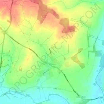
Name: Lavendon topographic map, elevation, terrain.
Location: Lavendon, City of Milton Keynes, England, United Kingdom (52.15943 -0.68780 52.19613 -0.62747)
Average elevation: 73 m
Minimum elevation: 41 m
Maximum elevation: 110 m
City of Milton Keynes trails, hiking, mountain biking, running and outdoor activities
Make a donation
Gear up for your next adventure:
As an Amazon Associate, this site earns from qualifying purchases at no extra cost to you.
Other topographic maps
Click on a map to view its topography, its elevation and its terrain.
Walton Lake
United Kingdom > England > City of Milton Keynes > Milton Keynes > Monkston
Average elevation: 73 m
Willen Lake
United Kingdom > England > City of Milton Keynes > Milton Keynes > Monkston
Average elevation: 67 m
Make a donation
Gear up for your next adventure:
As an Amazon Associate, this site earns from qualifying purchases at no extra cost to you.
Milton Keynes
United Kingdom > England > City of Milton Keynes > Milton Keynes
Average elevation: 90 m
Fenny Stratford
United Kingdom > England > City of Milton Keynes > Milton Keynes
Average elevation: 95 m