
Unterschächen topographic map
Interactive map
Click on the map to display elevation.
About this map
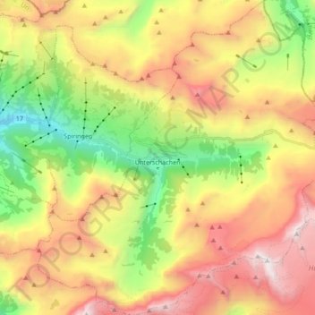
Name: Unterschächen topographic map, elevation, terrain.
Location: Unterschächen, Uri, 6465, Zwitserland (46.80682 8.70482 46.92242 8.85935)
Average elevation: 1,893 m
Minimum elevation: 693 m
Maximum elevation: 3,249 m
Other topographic maps
Click on a map to view its topography, its elevation and its terrain.
Piz Badus
Zwitserland > Uri > Korporation Ursern > Andermatt
Piz Badus, Andermatt, Korporation Ursern, Uri, 6490, Zwitserland
Average elevation: 2,410 m
Furkapass
Zwitserland > Uri > Realp
Furkapass, Realp, Korporation Ursern, Uri, 6491, Zwitserland
Average elevation: 2,470 m
Andermatt
Zwitserland > Uri > Korporation Ursern
Andermatt, Korporation Ursern, Uri, 6490, Zwitserland
Average elevation: 2,127 m
Oberalpstock
Zwitserland > Uri > Silenen
Oberalpstock, Silenen, Uri, Zwitserland
Average elevation: 2,711 m