
Seelisberg topographic map
Interactive map
Click on the map to display elevation.
About this map
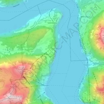
Name: Seelisberg topographic map, elevation, terrain.
Location: Seelisberg, Uri, 6377, Zwitserland (46.92260 8.54357 46.99341 8.60439)
Average elevation: 797 m
Minimum elevation: 414 m
Maximum elevation: 2,088 m
Other topographic maps
Click on a map to view its topography, its elevation and its terrain.
Piz Badus
Zwitserland > Uri > Korporation Ursern > Andermatt
Piz Badus, Andermatt, Korporation Ursern, Uri, 6490, Zwitserland
Average elevation: 2,410 m
Furkapass
Zwitserland > Uri > Realp
Furkapass, Realp, Korporation Ursern, Uri, 6491, Zwitserland
Average elevation: 2,470 m
Andermatt
Zwitserland > Uri > Korporation Ursern
Andermatt, Korporation Ursern, Uri, 6490, Zwitserland
Average elevation: 2,127 m
Oberalpstock
Zwitserland > Uri > Silenen
Oberalpstock, Silenen, Uri, Zwitserland
Average elevation: 2,711 m