
Majadita topographic map
Interactive map
Click on the map to display elevation.
About this map
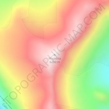
Name: Majadita topographic map, elevation, terrain.
Location: Majadita, Iglesia, San Juan, Argentina (-30.42012 -69.78098 -30.42002 -69.78088)
Average elevation: 5,968 m
Minimum elevation: 5,513 m
Maximum elevation: 6,260 m
Other topographic maps
Click on a map to view its topography, its elevation and its terrain.
Cerro Bayo
Cerro Bayo, Valle Fértil, San Juan, Argentina
Average elevation: 1,268 m
Barrio Robledal
Barrio Robledal, Capital, San Juan, Argentina
Average elevation: 648 m
Villa Mascarel
Villa Mascarel, Rawson, San Juan, 5423, Argentina
Average elevation: 622 m