
Torc topographic map
Interactive map
Click on the map to display elevation.
About this map
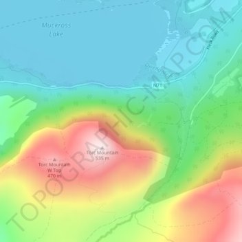
Name: Torc topographic map, elevation, terrain.
Average elevation: 185 m
Minimum elevation: 13 m
Maximum elevation: 522 m
Other topographic maps
Click on a map to view its topography, its elevation and its terrain.
Coolnahila (Palmer)
Ireland > County Limerick > The Municipal District of Cappamore — Kilmallock
Average elevation: 39 m
Brandon Hill
Brandon Hill (Irish: Cnoc Bhréanail) is the highest mountain in County Kilkenny, Ireland, with an elevation of 515 m (1,690 ft) and prominence at 448 m (1,470 ft). The South Leinster Way, a long-distance trail, meandering through the Barrow Valley and traverses Brandon Hill. The village of Graiguenamanagh and…
Average elevation: 294 m
Templeglantine
Ireland > County Limerick > The Municipal District of Newcastle West
Average elevation: 189 m