
Diễn Châu District topographic map
Interactive map
Click on the map to display elevation.
About this map
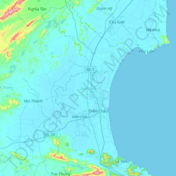
Name: Diễn Châu District topographic map, elevation, terrain.
Location: Diễn Châu District, Nghệ An Province, Vietnam (18.86027 105.48818 19.18287 105.65702)
Average elevation: 24 m
Minimum elevation: -1 m
Maximum elevation: 435 m
Other topographic maps
Click on a map to view its topography, its elevation and its terrain.
Bản Lốc
Vietnam > Nghe An province > Quế Phong District
Bản Lốc, Quế Phong District, Nghệ An Province, Vietnam
Average elevation: 336 m
Nghi Lộc District
Vietnam > Nghe An province > Nghi Lộc District
Nghi Lộc District, Nghe An province, 460000, Vietnam
Average elevation: 32 m
Tân Lập
Vietnam > Nghe An province > Tân Lập
Tân Lập, Tân Kỳ District, Nghe An province, Vietnam
Average elevation: 83 m