
Make a donation
Gear up for your next adventure:
As an Amazon Associate, this site earns from qualifying purchases at no extra cost to you.
Dolpa topographic map
Click on the map to display elevation.
Make a donation
Gear up for your next adventure:
As an Amazon Associate, this site earns from qualifying purchases at no extra cost to you.
Dolpa
Dolpa is the largest district of Nepal covering 5.36% of the total landmass of the country. It is located at 28°43’N to 29°43’N latitude and 82°23’E to 83°41’E longitude. Elevation ranges from 1,525 to 7,625 m (5,003 to 25,016 ft). The district borders Tibet on the north and northeast, Jumla and Mugu districts on the west, Myagdi, Jajarkot, Western and Eastern Rukum on the south, and Mustang on the east.
Make a donation
Gear up for your next adventure:
As an Amazon Associate, this site earns from qualifying purchases at no extra cost to you.
About this map
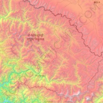
Name: Dolpa topographic map, elevation, terrain.
Location: Dolpa, Karnali Province, Nepal (28.72190 82.39256 29.70741 83.67995)
Average elevation: 4,555 m
Minimum elevation: 972 m
Maximum elevation: 8,065 m
Make a donation
Gear up for your next adventure:
As an Amazon Associate, this site earns from qualifying purchases at no extra cost to you.
Other topographic maps
Click on a map to view its topography, its elevation and its terrain.
Make a donation
Gear up for your next adventure:
As an Amazon Associate, this site earns from qualifying purchases at no extra cost to you.
Make a donation
Gear up for your next adventure:
As an Amazon Associate, this site earns from qualifying purchases at no extra cost to you.
Make a donation
Gear up for your next adventure:
As an Amazon Associate, this site earns from qualifying purchases at no extra cost to you.
Simikot
Nepal > Karnali Province > Humla
Lying at an altitude of just over 2,900m on a gentle slope high above the Humla Karnali River, Simikot lies on an ancient trade-cum-pilgrimage route to Mount Kailash. Mount Kailash is located in the Purang County of the Tibetan Autonomous Region, China, which borders Humla district of Nepal to the north. In…
Average elevation: 3,100 m
Make a donation
Gear up for your next adventure:
As an Amazon Associate, this site earns from qualifying purchases at no extra cost to you.
Make a donation
Gear up for your next adventure:
As an Amazon Associate, this site earns from qualifying purchases at no extra cost to you.
Make a donation
Gear up for your next adventure:
As an Amazon Associate, this site earns from qualifying purchases at no extra cost to you.
Simikot
Nepal > Karnali Province > Humla
Lying at an altitude of just over 2,900m on a gentle slope high above the Humla Karnali River, Simikot lies on an ancient trade-cum-pilgrimage route to Mount Kailash. Mount Kailash is located in the Purang County of the Tibetan Autonomous Region, China, which borders Humla district of Nepal to the north. In…
Average elevation: 3,100 m
Make a donation
Gear up for your next adventure:
As an Amazon Associate, this site earns from qualifying purchases at no extra cost to you.
Make a donation
Gear up for your next adventure:
As an Amazon Associate, this site earns from qualifying purchases at no extra cost to you.