
Mugu topographic map
Interactive map
Click on the map to display elevation.
Mugu
The remote Mugu district is rich in natural resources. Nepal's largest Rara Lake lies in this district. Many domestic and international tourists come to visit the famous and beautiful Rara Lake. The lake is also known as the Mahendra Tal. The Lake lies at an elevation of 2,990 meters and covers about 10.8 km2 (4.2 sq mi) of area. The Rara National Park protects and surrounds it.Mugu is known as underdeveloped district of Nepal.
About this map
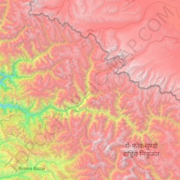
Name: Mugu topographic map, elevation, terrain.
Location: Mugu, Karnali Province, 21100, Nepal (29.38535 81.76256 29.97243 82.82910)
Average elevation: 4,482 m
Minimum elevation: 1,605 m
Maximum elevation: 6,761 m
Other topographic maps
Click on a map to view its topography, its elevation and its terrain.
Dolpa
Dolpa is the largest district of Nepal covering 5.36% of the total landmass of the country. It is located at 28°43’N to 29°43’N latitude and 82°23’E to 83°41’E longitude. Elevation ranges from 1,525 to 7,625 m (5,003 to 25,016 ft). The district borders Tibet on the north and northeast, Jumla and…
Average elevation: 4,555 m
Jumla
Geographically, Jumla is a Himalayan mountainous region of which elevations ranges from 915 metres (3,002 ft) to 4,679 metres (15,351 ft). The Higher Himalayan Region consists of Patarasi and Kanjirowa Himalayan ranges. The major rivers in Jumla are Hima, Tila and Jawa.
Average elevation: 3,373 m
Dailekh
Dailekh is a high, hilly district out of ten districts of Karnali Province. It is situated at coordinates of 28° 35' 00" N to 29° 08' 00" N Latitudes and 81° 25' 00" E to 81° 53' 00" E of Longitudes. The lowest elevation is 544m and the highest elevation is 4,168m. The headquarter is situated at an…
Average elevation: 1,701 m
Shey Phoksundo National Park
Shey Phoksundo National Park is the largest and only trans-Himalayan national park in Nepal. It was established in 1984 and covers an area of 3,555 km2 (1,373 sq mi) in the districts of Dolpa and Mugu in the Mid-Western Region, Nepal. The protected area ranges in elevation from 2,130 to 6,885 m (6,988 to…
Average elevation: 4,568 m
Salyan
From 1992 to 2002 a definitive series of large scale topographic maps were surveyed and published through a joint project by Government of Nepal Survey Department and Finland's Ministry for Foreign Affairs contracting through the FinnMap consulting firm. Japan International Cooperation Agency substituted for…
Average elevation: 1,238 m