
Schwyz topographic map
Interactive map
Click on the map to display elevation.
Schwyz
The highest elevation is the Bös Fulen at 2,802 m (9,193 ft). Although not as high, the summits of the Rigi massif (Kulm, 1,798 m [5,899 ft], and Scheidegg, 1,665 m [5,463 ft]) are probably the most famous mountains within the borders of the canton.
About this map
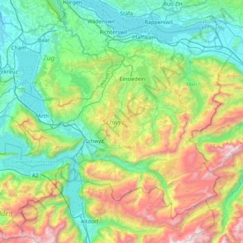
Name: Schwyz topographic map, elevation, terrain.
Location: Schwyz, Switzerland (46.88529 8.38874 47.22257 9.00471)
Average elevation: 1,081 m
Minimum elevation: 387 m
Maximum elevation: 3,006 m
Other topographic maps
Click on a map to view its topography, its elevation and its terrain.
Berninapass
Switzerland > Grisons > Maloja > Pontresina
The building of the road began in 1842. Head of engineers was Rudolf Albertini (1821–1896) from Zuoz. The work was finished in 1865 and a hospice at an elevation of 2,307 metres (7,569 ft) was also opened. Since this time the road has been widened several times. Since 1965 it has been open all year round,…
Average elevation: 2,351 m
Sigriswiler Rothorn
Switzerland > Bern > Thun administrative district > Sigriswil
Average elevation: 1,552 m
Faulensee
Switzerland > Bern > Frutigen-Niedersimmental administrative district > Spiez
Average elevation: 638 m
Le Crêt
Switzerland > Vaud > District de la Riviera-Pays-d’Enhaut > Rougemont
Average elevation: 1,229 m
Fürten
Switzerland > Bern > Frutigen-Niedersimmental administrative district > Kandergrund
Average elevation: 1,402 m
Eiger
Switzerland > Bern > Interlaken-Oberhasli administrative district > Grindelwald
Average elevation: 2,944 m
Triftsee
Switzerland > Bern > Interlaken-Oberhasli administrative district > Innertkirchen
Average elevation: 2,025 m
Schwarzhoren
Switzerland > Bern > Interlaken-Oberhasli administrative district > Grindelwald
Average elevation: 2,468 m
Piz Linard
Switzerland > Grisons > Region Engiadina Bassa/Val Müstair > Zernez
Average elevation: 2,626 m
Rheinquelle
Switzerland > Grisons > Surselva > Tujetsch
The Swiss Federal Office of Topography and ETH Zürich indicate a point north of Lake Toma and the Rein da Tuma as the source of the Rhine (and also of the Vorderrhein), and as the source of the Hinterrhein a point in the upper valley of the Rheinwald, east of the Rheinwaldhorn.
Average elevation: 2,435 m
Underburg
Switzerland > Bern > Interlaken-Oberhasli administrative district > Innertkirchen > Wychel
Average elevation: 912 m
Passo dell'Alpe di Neggia
Switzerland > Ticino > Distretto di Locarno > Gambarogno > Rii
Average elevation: 1,319 m
Haslemer Weier
Switzerland > Schaffhausen > Bezirk Unterklettgau > Osterfingen > Gwelb
Average elevation: 437 m
Oberwald
Switzerland > Wallis > Goms > Obergoms
It is situated at an elevation of 1,377 m and had a population of 277 in December 2007. It is located at the end of the Goms, directly before the Furka and Grimsel passes, underneath the Rhône River source at the Rhône Glacier. It is also the startpoint of the Furka Tunnel and is served by Oberwald railway…
Average elevation: 1,744 m
Jungfraujoch
Switzerland > Bern > Interlaken-Oberhasli administrative district > Lauterbrunnen
The Jungfraujoch (German: lit. "maiden saddle") is a saddle connecting two major 4000ers of the Bernese Alps: the Jungfrau and the Mönch. It lies at an elevation of 3,463 metres (11,362 ft) above sea level and is directly overlooked by the rocky prominence of the Sphinx. The Jungfraujoch is a glacier saddle,…
Average elevation: 3,307 m
Jungfrau
Switzerland > Bern > Interlaken-Oberhasli administrative district > Lauterbrunnen
The difference of altitude between the deep valley of Lauterbrunnen (800 m or 2,600 ft) and the summit is particularly visible from the area of Mürren. From the valley floor, west of the massif, the altitude gain is more than 3 km (1.9 mi) for a horizontal distance of 4 km (2.5 mi).
Average elevation: 3,401 m
Jungfraujoch
Switzerland > Bern > Interlaken-Oberhasli administrative district > Lauterbrunnen
The Jungfraujoch (German: lit. "maiden saddle") is a saddle connecting two major 4000ers of the Bernese Alps: the Jungfrau and the Mönch. It lies at an elevation of 3,463 metres (11,362 ft) above sea level and is directly overlooked by the rocky prominence of the Sphinx. The Jungfraujoch is a glacier saddle,…
Average elevation: 3,307 m
Gantrisch
Switzerland > Bern > Bern-Mittelland administrative district > Rüeggisberg
Average elevation: 1,776 m
Harderkulm
Switzerland > Bern > Interlaken-Oberhasli administrative district > Unterseen
Average elevation: 891 m
Schilthorn
Switzerland > Bern > Interlaken-Oberhasli administrative district > Lauterbrunnen
Average elevation: 2,455 m
Kiental
Switzerland > Bern > Frutigen-Niedersimmental administrative district > Reichenbach im Kandertal
Since 1910, the nearby mountain of Niesen (altitude 2,362 m [7,749 ft]) can be ascended at gradients of up to 68% via the Niesenbahn, which with a length of 3,499 m (11,480 ft) is the longest funicular railway in Europe.
Average elevation: 1,509 m
Möösli
Switzerland > Bern > Interlaken-Oberhasli administrative district > Interlaken
Average elevation: 674 m