
Differdange topographic map
Interactive map
Click on the map to display elevation.
Differdange
Differdange has an altitude of 293 meters, the highest point of the municipality being at 427,1m at Koufeld.
About this map
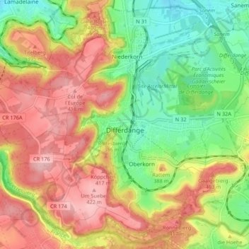
Name: Differdange topographic map, elevation, terrain.
Location: Differdange, Canton Esch-sur-Alzette, Luxembourg (49.49653 5.83412 49.54746 5.91632)
Average elevation: 352 m
Minimum elevation: 277 m
Maximum elevation: 427 m
Other topographic maps
Click on a map to view its topography, its elevation and its terrain.