
Belvaux topographic map
Interactive map
Click on the map to display elevation.
About this map
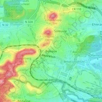
Name: Belvaux topographic map, elevation, terrain.
Location: Belvaux, Sanem, Canton Esch-sur-Alzette, 4450, Luxembourg (49.49281 5.91542 49.53281 5.95542)
Average elevation: 327 m
Minimum elevation: 288 m
Maximum elevation: 411 m
Other topographic maps
Click on a map to view its topography, its elevation and its terrain.
Differdange
Luxembourg > Canton Esch-sur-Alzette
Differdange has an altitude of 293 meters, the highest point of the municipality being at 427,1m at Koufeld.
Average elevation: 352 m