
Belle Mare topographic map
Interactive map
Click on the map to display elevation.
About this map
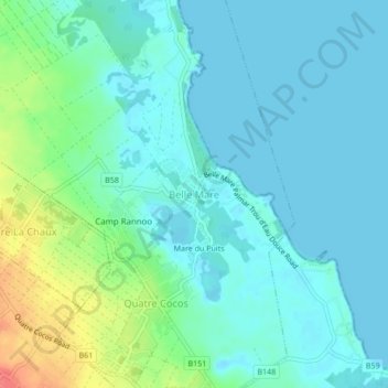
Name: Belle Mare topographic map, elevation, terrain.
Location: Belle Mare, Quatre Cocos, Flacq, 41601, Mauritius (-20.21834 57.75473 -20.17834 57.79473)
Average elevation: 13 m
Minimum elevation: 0 m
Maximum elevation: 58 m
Other topographic maps
Click on a map to view its topography, its elevation and its terrain.