
Make a donation
Gear up for your next adventure:
As an Amazon Associate, this site earns from qualifying purchases at no extra cost to you.
West Bank topographic map
Click on the map to display elevation.
Make a donation
Gear up for your next adventure:
As an Amazon Associate, this site earns from qualifying purchases at no extra cost to you.
West Bank
The West Bank has an area of 5,628 square kilometres (2,173 sq mi), which comprises 21.2% of former Mandatory Palestine (excluding Jordan) and has generally rugged mountainous terrain. The total length of the land boundaries of the region are 404 kilometres (251 miles). The terrain is mostly rugged dissected upland, some vegetation in the west, but somewhat barren in the east. The elevation span between the shoreline of the Dead Sea at −408 m to the highest point at Mount Nabi Yunis, at 1,030 m (3,379 ft) above sea level. The area of West Bank is landlocked; highlands are main recharge area for Israel's coastal aquifers.
Make a donation
Gear up for your next adventure:
As an Amazon Associate, this site earns from qualifying purchases at no extra cost to you.
About this map
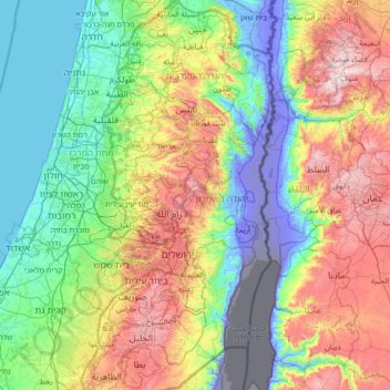
Name: West Bank topographic map, elevation, terrain.
Location: West Bank, Palestinian Territory (31.36631 34.90205 32.54894 35.54036)
Average elevation: 291 m
Minimum elevation: -415 m
Maximum elevation: 1,236 m
Make a donation
Gear up for your next adventure:
As an Amazon Associate, this site earns from qualifying purchases at no extra cost to you.
Other topographic maps
Click on a map to view its topography, its elevation and its terrain.
Nablus
Palestinian Territory > Area A
Insofar as the hilly topography of the site would allow, the city was built on a Roman grid plan and settled with veterans who fought in the victorious legions and other foreign colonists. In the 2nd century CE, Emperor Hadrian built a grand theater in Neapolis that could seat up to 7,000 people. Coins found…
Average elevation: 645 m
Sanur
Palestinian Territory > Area A
Sanur is located in the highlands of the northern West Bank. The village is situated on an isolated hilltop along the western edge of the valley and seasonal lake of Marj Sanur, which is named after the village. To the west, Sanur is connected to the Hawarah Ridge of the Zawiya Highlands through a low-lying…
Average elevation: 423 m
Make a donation
Gear up for your next adventure:
As an Amazon Associate, this site earns from qualifying purchases at no extra cost to you.
Make a donation
Gear up for your next adventure:
As an Amazon Associate, this site earns from qualifying purchases at no extra cost to you.
Make a donation
Gear up for your next adventure:
As an Amazon Associate, this site earns from qualifying purchases at no extra cost to you.
Nabi Daniel
Palestinian Territory > Judea and Samaria > Area C > Beitar Ilit > Sde Boaz
Average elevation: 885 m
Make a donation
Gear up for your next adventure:
As an Amazon Associate, this site earns from qualifying purchases at no extra cost to you.
Talmon
Palestinian Territory > Judea and Samaria > Area C
Located at an elevation of nearly 600 metres and 18 km east of Modiin, it is organised as a community settlement and falls under the jurisdiction of Mateh Binyamin Regional Council. In 2022, it had a population of 5,379.
Average elevation: 522 m
Make a donation
Gear up for your next adventure:
As an Amazon Associate, this site earns from qualifying purchases at no extra cost to you.
Khallet Afana
Palestinian Territory > Judea and Samaria > Area C > Beitar Ilit
Average elevation: 909 m
Make a donation
Gear up for your next adventure:
As an Amazon Associate, this site earns from qualifying purchases at no extra cost to you.
Nablus
Palestinian Territory > Area A
Insofar as the hilly topography of the site would allow, the city was built on a Roman grid plan and settled with veterans who fought in the victorious legions and other foreign colonists. In the 2nd century CE, Emperor Hadrian built a grand theater in Neapolis that could seat up to 7,000 people. Coins found…
Average elevation: 645 m
Make a donation
Gear up for your next adventure:
As an Amazon Associate, this site earns from qualifying purchases at no extra cost to you.
Make a donation
Gear up for your next adventure:
As an Amazon Associate, this site earns from qualifying purchases at no extra cost to you.
Make a donation
Gear up for your next adventure:
As an Amazon Associate, this site earns from qualifying purchases at no extra cost to you.
Homesh
Palestinian Territory > Judea and Samaria > Area C > Shomron Regional Council
Average elevation: 452 m
Mevo Dotan
Palestinian Territory > Judea and Samaria > Area C > Shomron Regional Council
Average elevation: 264 m
Make a donation
Gear up for your next adventure:
As an Amazon Associate, this site earns from qualifying purchases at no extra cost to you.
Make a donation
Gear up for your next adventure:
As an Amazon Associate, this site earns from qualifying purchases at no extra cost to you.
Make a donation
Gear up for your next adventure:
As an Amazon Associate, this site earns from qualifying purchases at no extra cost to you.
Make a donation
Gear up for your next adventure:
As an Amazon Associate, this site earns from qualifying purchases at no extra cost to you.
Make a donation
Gear up for your next adventure:
As an Amazon Associate, this site earns from qualifying purchases at no extra cost to you.
Make a donation
Gear up for your next adventure:
As an Amazon Associate, this site earns from qualifying purchases at no extra cost to you.
Make a donation
Gear up for your next adventure:
As an Amazon Associate, this site earns from qualifying purchases at no extra cost to you.
Make a donation
Gear up for your next adventure:
As an Amazon Associate, this site earns from qualifying purchases at no extra cost to you.
Rotem
Palestinian Territory > Judea and Samaria > Area C > Arvot Hayarden Regional Council
Average elevation: -120 m
Make a donation
Gear up for your next adventure:
As an Amazon Associate, this site earns from qualifying purchases at no extra cost to you.
Qalandiya Refugee Camp
Palestinian Territory > Area C > Qalandiya Refugee Camp
Average elevation: 737 m
Make a donation
Gear up for your next adventure:
As an Amazon Associate, this site earns from qualifying purchases at no extra cost to you.
Meithalun
Palestinian Territory > Area A > Meithalun
The town is situated along the western edge of Marj Sanur, a valley and seasonal lake. It is the largest locality, of seven total, bordering Marj Sanur and controls the largest share of its fertile lands. It has an average elevation of 385 meters above sea level and is not elevated from its immediate…
Average elevation: 403 m
Make a donation
Gear up for your next adventure:
As an Amazon Associate, this site earns from qualifying purchases at no extra cost to you.
Make a donation
Gear up for your next adventure:
As an Amazon Associate, this site earns from qualifying purchases at no extra cost to you.
Make a donation
Gear up for your next adventure:
As an Amazon Associate, this site earns from qualifying purchases at no extra cost to you.
Beit Fajjar
Palestinian Territory > Area B
The site's high altitude was the highest point in the area and later the town expanded into other hills. During British rule in Palestine in the 1920s-1940s, Beit Fajjar was used as an observation point for the Bethlehem-Hebron area.
Average elevation: 878 m