
Saxony topographic map
Interactive map
Click on the map to display elevation.
About this map
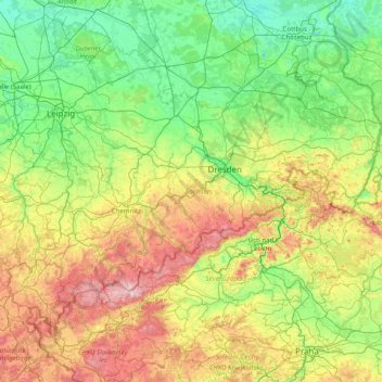
Name: Saxony topographic map, elevation, terrain.
Location: Saxony, Germany (50.17133 11.87225 51.68513 15.04193)
Average elevation: 290 m
Minimum elevation: 40 m
Maximum elevation: 1,235 m
The Ore Mountains in southern Saxony are traditionally a region of winter sports. The ski ressort of Oberwiesenthal is the highest town of Germany, at an altitude of 900 m, though the surrounding mountains do not reach the same height as in the alpine areas of Southern Germany. Thus, climate change is posing a certain threat to the development of winter sports business. There are a number of training facilities for the German Winter Olympics' team in the region.
Other topographic maps
Click on a map to view its topography, its elevation and its terrain.
Stuttgart
Germany > Baden-Württemberg > Stuttgart
Stuttgart, Regierungsbezirk Stuttgart, Baden-Württemberg, 70173, Germany
Average elevation: 353 m
Aachen
Germany > North Rhine-Westphalia > Städteregion Aachen
Aachen, Städteregion Aachen, North Rhine-Westphalia, Germany
Average elevation: 225 m
Bergham
Germany > Bavaria > Landkreis Rottal-Inn
Bergham, Kirchdorf am Inn, Landkreis Rottal-Inn, Bavaria, 84387, Germany
Average elevation: 362 m
Burgham
Germany > Bavaria > Landkreis Traunstein > Seeon-Seebruck
Burgham, Seeon-Seebruck, Landkreis Traunstein, Bavaria, 83358, Germany
Average elevation: 525 m
Frankfurt am Main
Germany > Hesse > Frankfurt am Main
Frankfurt am Main, Hesse, 60311, Germany
Average elevation: 162 m
Lauchröden
Germany > Thuringia > Wartburgkreis
Lauchröden, Gerstungen, Wartburgkreis, Thuringia, 99819, Germany
Average elevation: 242 m
Alperstedt
Germany > Thuringia > Landkreis Sömmerda
Alperstedt, Gramme-Vippach, Landkreis Sömmerda, Thuringia, 99195, Germany
Average elevation: 159 m
Cologne
Germany > North Rhine – Westphalia
Cologne, North Rhine-Westphalia, Germany
Average elevation: 69 m
Oberkatz
Germany > Thuringia > Landkreis Schmalkalden-Meiningen > Kaltennordheim
Oberkatz, Kaltennordheim, Hohe Rhön, Landkreis Schmalkalden-Meiningen, Thuringia, Germany
Average elevation: 538 m
Saalbach
Germany > Baden-Württemberg > Landkreis Karlsruhe
Saalbach, Landkreis Karlsruhe, Baden-Württemberg, Germany
Average elevation: 142 m
Hohen Viecheln
Germany > Mecklenburg-Vorpommern > Nordwestmecklenburg
Hohen Viecheln, Dorf Mecklenburg-Bad Kleinen, Nordwestmecklenburg, Mecklenburg-Vorpommern, Germany
Average elevation: 46 m
Kleiner Brombachsee
Germany > Bavaria > Weißenburg-Gunzenhausen > Langlau
Kleiner Brombachsee, Langlau, Pfofeld, Gunzenhausen (VGem), Weißenburg-Gunzenhausen, Bavaria, Germany
Average elevation: 427 m
Landkreis Weimarer Land
Landkreis Weimarer Land, Thuringia, Germany
Average elevation: 291 m
Mariental
Germany > Lower Saxony > Landkreis Helmstedt
Mariental, Samtgemeinde Grasleben, Landkreis Helmstedt, Lower Saxony, Germany
Average elevation: 142 m
Möhnesee
Germany > North Rhine – Westphalia > Kreis Soest
Möhnesee, Kreis Soest, North Rhine – Westphalia, 59519, Germany
Average elevation: 265 m
Ismaninger Speichersee und Fischteiche
Germany > Bavaria > Landkreis München > Unterföhring
Ismaninger Speichersee und Fischteiche, Unterföhring, Kirchheim bei München, Landkreis München, Bavaria, Germany
Average elevation: 496 m
Elten
Germany > North Rhine – Westphalia > Kreis Kleve > Emmerich on the Rhine
Elten, Emmerich on the Rhine, Kreis Kleve, North Rhine – Westphalia, Germany
Average elevation: 21 m
Langeneß
Germany > Schleswig-Holstein > Northern Friesland > Langeneß
Langeneß, Pellworm, Northern Friesland, Schleswig-Holstein, 25863, Germany
Average elevation: 0 m
Nürburg
Germany > Rhineland-Palatinate > Landkreis Ahrweiler
Nürburg, Adenau, Landkreis Ahrweiler, Rhineland-Palatinate, Germany
Average elevation: 560 m
Ergoldsbach
Germany > Bavaria > Landkreis Landshut
Ergoldsbach, Ergoldsbach (VGem), Landkreis Landshut, Bavaria, 84061, Germany
Average elevation: 454 m
Illertissen
Germany > Bavaria > Landkreis Neu-Ulm
Illertissen, Landkreis Neu-Ulm, Bavaria, 89257, Germany
Average elevation: 522 m
99718
Germany > Thuringia > Kyffhäuserkreis > Wasserthaleben
99718, Wasserthaleben, Greußen, Kyffhäuserkreis, Thuringia, Germany
Average elevation: 235 m
Bremen
Germany > Free Hanseatic City of Bremen
Bremen, Free Hanseatic City of Bremen, Germany
Average elevation: 11 m
Wind
Germany > Bavaria > Landkreis Bamberg
Wind, Pommersfelden, Landkreis Bamberg, Bavaria, 96178, Germany
Average elevation: 284 m
Waldesch
Germany > Rhineland-Palatinate > Landkreis Mayen-Koblenz
Waldesch, Rhein-Mosel, Landkreis Mayen-Koblenz, Rhineland-Palatinate, 56323, Germany
Average elevation: 331 m
Horn-Bad Meinberg
Germany > North Rhine – Westphalia > Kreis Lippe
Horn-Bad Meinberg, Kreis Lippe, North Rhine – Westphalia, 32805, Germany
Average elevation: 238 m
Meinberg
Germany > Bavaria > Landkreis Bayreuth > Goldkronach
Meinberg, Goldkronach, Landkreis Bayreuth, Bavaria, 95497, Germany
Average elevation: 450 m
Bad Orb
Germany > Hesse > Main-Kinzig-Kreis
Bad Orb, Main-Kinzig-Kreis, Hesse, 63619, Germany
Average elevation: 325 m
Bad Saulgau
Germany > Baden-Württemberg > Landkreis Sigmaringen
Bad Saulgau, Verwaltungsgemeinschaft Bad Saulgau, Landkreis Sigmaringen, Baden-Württemberg, 88348, Germany
Average elevation: 613 m
Langen
Germany > Hesse > Landkreis Offenbach
Langen, Landkreis Offenbach, Hesse, 63225, Germany
Average elevation: 137 m
Ebringen
Germany > Baden-Württemberg > Landkreis Breisgau-Hochschwarzwald
Ebringen, VVG der Gemeinde Schallstadt, Landkreis Breisgau-Hochschwarzwald, Baden-Württemberg, 79285, Germany
Average elevation: 354 m
Diedorf
Germany > Bavaria > Augsburg (district)
Diedorf, Augsburg (district), Bavaria, 86420, Germany
Average elevation: 506 m
Hinterkaifeck
Germany > Bavaria > Landkreis Neuburg-Schrobenhausen > Gröbern
Hinterkaifeck, Gröbern, Waidhofen, Schrobenhausen, Landkreis Neuburg-Schrobenhausen, Bavaria, 86579, Germany
Average elevation: 423 m
Oberhorbach
Germany > North Rhine – Westphalia > Rhein-Sieg-Kreis > Neunkirchen-Seelscheid
Oberhorbach, Eischeid, Neunkirchen-Seelscheid, Rhein-Sieg-Kreis, North Rhine – Westphalia, 53819, Germany
Average elevation: 183 m
Klein Förste
Germany > Lower Saxony > Landkreis Hildesheim
Klein Förste, Harsum, Landkreis Hildesheim, Lower Saxony, 31180, Germany
Average elevation: 76 m
Wehringen
Germany > Bavaria > Augsburg (district)
Wehringen, Augsburg (district), Bavaria, 86517, Germany
Average elevation: 533 m
Belecke
Germany > North Rhine – Westphalia > Kreis Soest > Warstein
Belecke, Warstein, Kreis Soest, North Rhine – Westphalia, 59581, Germany
Average elevation: 291 m