
Vardar topographic map
Interactive map
Click on the map to display elevation.
About this map
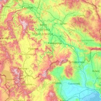
Name: Vardar topographic map, elevation, terrain.
Location: Vardar, 1000 SK, North Macedonia (40.51217 20.83696 42.10325 22.71698)
Average elevation: 691 m
Minimum elevation: -3 m
Maximum elevation: 2,556 m
Other topographic maps
Click on a map to view its topography, its elevation and its terrain.
Ohrid
North Macedonia > Southwestern Region > Ohrid
Ohrid is located in the south-western part of North Macedonia, on the shore of Lake Ohrid, at an elevation of 695 meters above sea level.
Average elevation: 963 m