
Racha topographic map
Interactive map
Click on the map to display elevation.
About this map
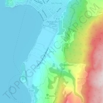
Name: Racha topographic map, elevation, terrain.
Location: Racha, Velestovo, Municipality of Ohrid, 6000, North Macedonia (41.07374 20.79202 41.11374 20.83202)
Average elevation: 838 m
Minimum elevation: 686 m
Maximum elevation: 1,284 m
Other topographic maps
Click on a map to view its topography, its elevation and its terrain.
Ohrid
Ohrid is located in the south-western part of North Macedonia, on the shore of Lake Ohrid, at an elevation of 695 meters above sea level.
Average elevation: 901 m
Ohrid
Ohrid is located in the south-western part of North Macedonia, on the shore of Lake Ohrid, at an elevation of 695 meters above sea level.
Average elevation: 901 m
Ohrid
Ohrid is located in the south-western part of North Macedonia, on the shore of Lake Ohrid, at an elevation of 695 meters above sea level.
Average elevation: 901 m