
Make a donation
Gear up for your next adventure:
As an Amazon Associate, this site earns from qualifying purchases at no extra cost to you.
Bitola topographic map
Click on the map to display elevation.
Make a donation
Gear up for your next adventure:
As an Amazon Associate, this site earns from qualifying purchases at no extra cost to you.
Bitola
Bitola is located in the southwestern part of North Macedonia. The Dragor River flows through the city. Bitola lies at an elevation of 615 metres above sea level, at the foot of Baba Mountain. Its magnificent Pelister mountain (2,601 m) is a national park with exquisite flora and fauna, among which is the rarest species of pine, known as Macedonian pine or pinus peuce. It is also the location of a well-known ski resort.
Make a donation
Gear up for your next adventure:
As an Amazon Associate, this site earns from qualifying purchases at no extra cost to you.
About this map
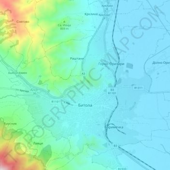
Name: Bitola topographic map, elevation, terrain.
Location: Bitola, Municipality of Bitola, 7000, North Macedonia (41.00278 21.28478 41.07848 21.38646)
Average elevation: 713 m
Minimum elevation: 579 m
Maximum elevation: 1,482 m
Make a donation
Gear up for your next adventure:
As an Amazon Associate, this site earns from qualifying purchases at no extra cost to you.
Other topographic maps
Click on a map to view its topography, its elevation and its terrain.
Make a donation
Gear up for your next adventure:
As an Amazon Associate, this site earns from qualifying purchases at no extra cost to you.
Make a donation
Gear up for your next adventure:
As an Amazon Associate, this site earns from qualifying purchases at no extra cost to you.
Ohrid
North Macedonia > Southwestern Region > Ohrid
Ohrid is located in the south-western part of North Macedonia, on the shore of Lake Ohrid, at an elevation of 695 meters above sea level.
Average elevation: 963 m
Make a donation
Gear up for your next adventure:
As an Amazon Associate, this site earns from qualifying purchases at no extra cost to you.
Make a donation
Gear up for your next adventure:
As an Amazon Associate, this site earns from qualifying purchases at no extra cost to you.
Make a donation
Gear up for your next adventure:
As an Amazon Associate, this site earns from qualifying purchases at no extra cost to you.