
Make a donation
Gear up for your next adventure:
As an Amazon Associate, this site earns from qualifying purchases at no extra cost to you.
Ohrid topographic map
Click on the map to display elevation.
Make a donation
Gear up for your next adventure:
As an Amazon Associate, this site earns from qualifying purchases at no extra cost to you.
Ohrid
Ohrid is located in the south-western part of North Macedonia, on the shore of Lake Ohrid, at an elevation of 695 meters above sea level.
Make a donation
Gear up for your next adventure:
As an Amazon Associate, this site earns from qualifying purchases at no extra cost to you.
About this map
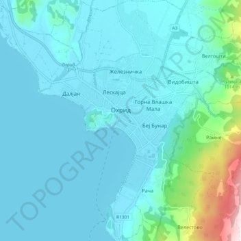
Name: Ohrid topographic map, elevation, terrain.
Location: Ohrid, Municipality of Ohrid, 6000, North Macedonia (41.07917 20.67480 41.14863 20.83036)
Average elevation: 901 m
Minimum elevation: 686 m
Maximum elevation: 1,653 m
Make a donation
Gear up for your next adventure:
As an Amazon Associate, this site earns from qualifying purchases at no extra cost to you.
Other topographic maps
Click on a map to view its topography, its elevation and its terrain.
Make a donation
Gear up for your next adventure:
As an Amazon Associate, this site earns from qualifying purchases at no extra cost to you.
Make a donation
Gear up for your next adventure:
As an Amazon Associate, this site earns from qualifying purchases at no extra cost to you.
Make a donation
Gear up for your next adventure:
As an Amazon Associate, this site earns from qualifying purchases at no extra cost to you.
Ohrid
North Macedonia > Southwestern Region > Ohrid
Ohrid is located in the south-western part of North Macedonia, on the shore of Lake Ohrid, at an elevation of 695 meters above sea level.
Average elevation: 963 m
Make a donation
Gear up for your next adventure:
As an Amazon Associate, this site earns from qualifying purchases at no extra cost to you.
Make a donation
Gear up for your next adventure:
As an Amazon Associate, this site earns from qualifying purchases at no extra cost to you.