
Sermenin topographic map
Interactive map
Click on the map to display elevation.
About this map
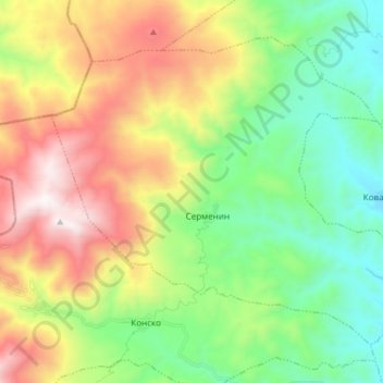
Name: Sermenin topographic map, elevation, terrain.
Location: Sermenin, Municipality of Gevgelija, North Macedonia (41.18059 22.28351 41.27223 22.43438)
Average elevation: 800 m
Minimum elevation: 225 m
Maximum elevation: 1,754 m
Other topographic maps
Click on a map to view its topography, its elevation and its terrain.
Ohrid
North Macedonia > Southwestern Region > Ohrid
Ohrid is located in the south-western part of North Macedonia, on the shore of Lake Ohrid, at an elevation of 695 meters above sea level.
Average elevation: 963 m