
Orkney Islands topographic map
Interactive map
Click on the map to display elevation.
About this map
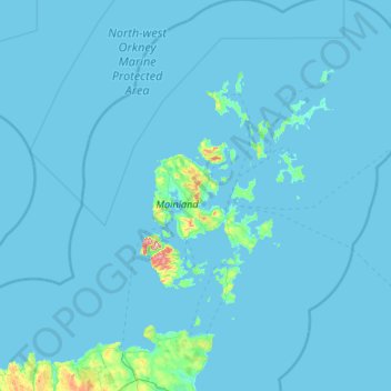
Name: Orkney Islands topographic map, elevation, terrain.
Location: Orkney Islands, Scotland, United Kingdom (58.67299 -4.50725 59.39974 -2.36801)
Average elevation: 7 m
Minimum elevation: 0 m
Maximum elevation: 460 m
The southern group of islands surrounds Scapa Flow. Hoy, to the west, is the second largest of the Orkney Isles and Ward Hill at its northern end is the highest elevation in the archipelago. The Old Man of Hoy is a well-known seastack. Graemsay and Flotta are both linked by ferry to the Mainland and Hoy, and the latter is known for its large oil terminal. South Walls has a 19th-century Martello tower and is connected to Hoy by the Ayre. Burray lies to the east of Scapa Flow and is linked by causeway to South Ronaldsay, which hosts cultural events such as the Festival of the Horse and the Boys' Ploughing Match on the third Saturday in August. It is also the location of the Neolithic Tomb of the Eagles. South Ronaldsay, Burray, Glimps Holm, and Lamb Holm are connected by road to the Mainland by the Churchill Barriers.
Other topographic maps
Click on a map to view its topography, its elevation and its terrain.
Edinburgh
United Kingdom > Scotland > Edinburgh
Edinburgh, City of Edinburgh, Scotland, EH1 3EG, United Kingdom
Average elevation: 104 m
Fort William
United Kingdom > Scotland > Highland
Fort William, Highland, Scotland, PH33 6AQ, United Kingdom
Average elevation: 122 m
City of Edinburgh
City of Edinburgh, Scotland, United Kingdom
Average elevation: 118 m
Scottish Borders
Scottish Borders, Scotland, United Kingdom
Average elevation: 257 m
Glasgow
United Kingdom > Scotland > Glasgow City
Glasgow, Glasgow City, Scotland, G2 1DY, United Kingdom
Average elevation: 128 m
Kinlocheil
United Kingdom > Scotland > Highland
Kinlocheil, Highland, Scotland, PH33 7NP, United Kingdom
Average elevation: 135 m
Humbie
United Kingdom > Scotland > East Lothian
Humbie, East Lothian, Scotland, EH36 5PJ, United Kingdom
Average elevation: 192 m
East Kilbride
United Kingdom > Scotland > East Kilbride
East Kilbride, South Lanarkshire, Scotland, United Kingdom
Average elevation: 177 m
Dunfermline
United Kingdom > Scotland > Fife > Dunfermline
Dunfermline, Fife, Scotland, United Kingdom
Average elevation: 80 m
Inverness
United Kingdom > Scotland > Highland
Inverness, Highland, Scotland, IV1 1AN, United Kingdom
Average elevation: 163 m
Blackburn
United Kingdom > Scotland > Aberdeenshire
Blackburn, Aberdeenshire, Scotland, United Kingdom
Average elevation: 102 m
Airlie
United Kingdom > Scotland > Angus
Airlie, Angus, Scotland, DD8 5HP, United Kingdom
Average elevation: 91 m
Skye
United Kingdom > Scotland > Highland
Skye, Highland, Scotland, United Kingdom
Average elevation: 63 m
Aviemore
United Kingdom > Scotland > Highland
Aviemore, Highland, Scotland, PH22 1RN, United Kingdom
Average elevation: 331 m
Clerklands
United Kingdom > Scotland > Scottish Borders
Clerklands, Scottish Borders, Scotland, TD6 9JR, United Kingdom
Average elevation: 212 m
High Valleyfield
United Kingdom > Scotland > Fife
High Valleyfield, Fife, Scotland, KY12 8NF, United Kingdom
Average elevation: 33 m
Perth and Kinross
Perth and Kinross, Scotland, United Kingdom
Average elevation: 338 m
Cairngorms National Park
Cairngorms National Park, Derry Dam Bridge, Aberdeenshire, Scotland, United Kingdom
Average elevation: 431 m
Ben Nevis
United Kingdom > Scotland > Highland
Ben Nevis, Highland, Scotland, United Kingdom
Average elevation: 912 m
St Andrews
United Kingdom > Scotland > Fife
St Andrews, Fife, Scotland, KY16 9PA, United Kingdom
Average elevation: 38 m
Pitlochry
United Kingdom > Scotland > Perth and Kinross
Pitlochry, Perth and Kinross, Scotland, PH16 5BX, United Kingdom
Average elevation: 276 m
Falkirk
United Kingdom > Scotland > Falkirk
Falkirk, Scotland, FK1 1ED, United Kingdom
Average elevation: 69 m
Aberdeen
United Kingdom > Scotland > Aberdeen
Aberdeen, Aberdeen City, Scotland, AB11 5EQ, United Kingdom
Average elevation: 52 m
Langlands Moss Local Nature Reserve
United Kingdom > Scotland > South Lanarkshire > East Kilbride
Langlands Moss Local Nature Reserve, Langlands Moss Boardwalk, Langlands Business & Technology Park, Kelvin, East Kilbride, South Lanarkshire, Scotland, G75 0YY, United Kingdom
Average elevation: 204 m
Norwick
United Kingdom > Scotland > Shetland > Saxa Vord
Norwick, Unst, Saxa Vord, Shetland, Scotland, ZE2 9EF, United Kingdom
Average elevation: 53 m
Isle of Arran
United Kingdom > Scotland > North Ayrshire
Isle of Arran, North Ayrshire, Scotland, United Kingdom
Average elevation: 98 m
Callanish
United Kingdom > Scotland > Western Isles
Callanish, Western Isles, Scotland, HS2 9DY, United Kingdom
Average elevation: 19 m
Aberdeenshire
Aberdeenshire, Scotland, United Kingdom
Average elevation: 199 m
Dundee
United Kingdom > Scotland > Dundee City
Dundee, Dundee City, Scotland, DD1 1SG, United Kingdom
Average elevation: 82 m
Laurencekirk
United Kingdom > Scotland > Aberdeenshire
Laurencekirk, Aberdeenshire, Scotland, AB30 1BZ, United Kingdom
Average elevation: 105 m
Glencoe
United Kingdom > Scotland > Highland
Glencoe, Highland, Scotland, PH49 4HS, United Kingdom
Average elevation: 114 m
Braid Wood
United Kingdom > Scotland > East Ayrshire
Braid Wood, East Ayrshire, Scotland, United Kingdom
Average elevation: 114 m
Waterloo
United Kingdom > Scotland > Perth and Kinross
Waterloo, Perth and Kinross, Scotland, PH1 4FG, United Kingdom
Average elevation: 115 m
Aberdeen City
Aberdeen City, Scotland, United Kingdom
Average elevation: 46 m
Livingston
United Kingdom > Scotland > West Lothian
Livingston, West Lothian, Scotland, EH54 6HS, United Kingdom
Average elevation: 158 m
Justinhaugh
United Kingdom > Scotland > Angus > Oathlaw
Justinhaugh, Oathlaw, Angus, Scotland, DD8 3SD, United Kingdom
Average elevation: 86 m
Dumfries and Galloway
Dumfries and Galloway, Scotland, United Kingdom
Average elevation: 163 m
Kilmarnock
United Kingdom > Scotland > East Ayrshire
Kilmarnock, East Ayrshire, Scotland, KA1 1HZ, United Kingdom
Average elevation: 56 m
Bankhead of Kirkbuddo
United Kingdom > Scotland > Angus
Bankhead of Kirkbuddo, Letham & District, Angus, Scotland, DD8 2NF, United Kingdom
Average elevation: 159 m
Glamis Castle
United Kingdom > Scotland > Angus > Forfar > Deanbank
Glamis Castle, Earl John's Bridge, Deanbank, Forfar, Angus, Scotland, DD8 1RJ, United Kingdom
Average elevation: 69 m
Padanaram
United Kingdom > Scotland > Angus > Forfar
Padanaram, Forfar, Angus, Scotland, DD8 1PT, United Kingdom
Average elevation: 68 m
Muirhouses
United Kingdom > Scotland > Falkirk
Muirhouses, Falkirk, Scotland, EH51 9SL, United Kingdom
Average elevation: 46 m
Colt Hill
United Kingdom > Scotland > Dumfries and Galloway
Colt Hill, Dumfries and Galloway, Scotland, DG3 4NN, United Kingdom
Average elevation: 470 m
Nellfield House
United Kingdom > Scotland > South Lanarkshire > Braidwood
Nellfield House, Braidwood, South Lanarkshire, Scotland, ML8 5GZ, United Kingdom
Average elevation: 195 m
Newtyle
United Kingdom > Scotland > Angus
Newtyle, Angus, Scotland, PH12 8TX, United Kingdom
Average elevation: 130 m