Geolocate

Selangor topographic map

Interactive map

Click on the map to display elevation.

Selangor

Topographically wise, Selangor is relatively level near the coast and gradually become more hilly and mountainous towards the east. The hill and mountain, surrounding the eastern and central portion of the state effectively forming a valley and a drainage basin of the Klang River, known as the Klang Valley, where most of the population are centered. The Klang Valley is often synonymously associated with another toponym, Greater Kuala Lumpur, though both terms vary between each other. Being one of the most heavily urbanized regions in Malaysia and Southeast Asia, cities that make up Klang Valley include the state and royal capitals of Shah Alam and Klang, as well as the federal capital, Kuala Lumpur, which is strategically situated in the heart of the state. It was once part of Selangor territory before it was ceded to the federal government in 1974 to form a Federal Territory. It was then followed by the 1995 cession of Prang Besar of Sepang District to the federal government, which became what is now the nation's administrative and judicial capital Putrajaya.

Wikipedia (CC-BY-SA 3.0)

About this map

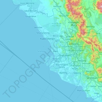
Name: Selangor topographic map, elevation, terrain.

Location: Selangor, Malaysia (2.40457 100.38751 3.87043 101.96981)

Average elevation: 98 m

Minimum elevation: -2 m

Maximum elevation: 2,048 m

Other topographic maps

Click on a map to view its topography, its elevation and its terrain.

Kuala Lumpur

Malaysia > Kuala Lumpur

Located in the centre of Selangor state, Kuala Lumpur was a territory of Selangor State Government. In 1974, Kuala Lumpur was split off from Selangor to form the first Federal Territory governed directly by the Malaysian federal government. Its location in the most developed state on the west coast of…

Average elevation: 127 m

Johor Bahru

Malaysia > Johor

Average elevation: 23 m

Siburan

Malaysia > Sarawak > Kuching

Average elevation: 27 m

Seremban

Malaysia > Negeri Sembilan

Average elevation: 168 m

Penang Island

Malaysia > Penang Island

Penang Island is irregularly shaped, with a hilly and mostly forested interior; its coastal plains are narrow, the most extensive of which is at the northeastern cape. With a height of 833 m (2,733 ft), Penang Hill, at the centre of the island, is the tallest point within Penang. From a small settlement at the…

Average elevation: 117 m

Broga

Malaysia > Negeri Sembilan

The hill, approximately 400 m (1,300 ft) in altitude, is notable for its unique appearance as it is rather devoid of trees, which is an uncommon sight amongst the tropical rainforests surrounding the region. Cogongrass typically dominates the summit area. Remnants of burnt out tree trunks indicate that the…

Average elevation: 141 m

Pahang

Malaysia > Pahang

The highest peak, Mount Tahan, reaches 2,187 m (7,175 ft) in elevation, which is also the highest point in the Peninsular Malaysia. The climate is temperate enough to have distinct temperature variations year round, and much of the highlands are covered with tropical rainforest. Pahang is home to Malaysia's…

Average elevation: 90 m

Sarawak River

Malaysia > Sarawak > Kuching

Average elevation: 6 m

Klang

Malaysia > Selangor > Klang

Average elevation: 13 m

Kuching

Malaysia > Sarawak > Kuching

Average elevation: 17 m

Ipoh

Malaysia > Perak > Majlis Bandaraya Ipoh

Average elevation: 205 m

Johor Bahru

Malaysia > Johor

Average elevation: 23 m

Genting Highlands

Malaysia > Pahang

Genting Highlands is a hill station and a city located on the peak of Mount Ulu Kali in the Titiwangsa Mountains, central Peninsular Malaysia, at 1800 metres elevation. It is the second seat of Bentong District after Bentong. Located in the state of Pahang. It was established in 1965 by the late Malaysian…

Average elevation: 1,141 m

Skudai

Malaysia > Johor > Iskandar Puteri

Average elevation: 29 m

Seri Iskandar

Malaysia > Perak

Seri Iskandar (Jawi: سري إسكندر, Chinese: 斯里依斯干达) is a major town within the Perak Tengah District in the state of Perak, Malaysia. It is situated about 40 kilometers southwest of the city of Ipoh, the state capital. The town is at an average elevation of 29 meters above the sea level. The…

Average elevation: 29 m

Semenyih

Malaysia > Selangor > Kajang Municipal Council

Average elevation: 62 m

Sibu

Malaysia > Sarawak > Sibu

Sibu is located near the Rajang delta at the confluence of Rajang and Igan rivers. Peat swamp forests and alluvial plains are particularly prevalent in the Sibu Division. Sibu is located on a deep peat soil, which has caused problems in infrastructure development because buildings and roads slowly sink into…

Average elevation: 10 m

Kangar

Malaysia > Perlis

Average elevation: 28 m

Kundasang

Malaysia > Sabah > Ranau

Average elevation: 1,279 m

Cameron Highlands

Malaysia > Pahang

Surveyed by the government geologist and explorer William Cameron in 1885, the outpost consists of three mukims (subdistricts), namely Ringlet, Tanah Rata and Ulu Telom. Its eight settlements are Ringlet, Tanah Rata (the administrative centre), Brinchang, the Bertam Valley, Kea Farm, Tringkap, Kampung Kuala…

Average elevation: 1,400 m

Sungai Kenaboi

Malaysia > Negeri Sembilan

Average elevation: 523 m

Bukit Batu Sawa

Malaysia > Negeri Sembilan

Average elevation: 206 m

Lata Penyel

Malaysia > Perak > Kampung Org Asli Pendeq

Average elevation: 602 m

Puchong

Malaysia > Selangor > Subang Jaya City Council

Average elevation: 38 m

Puchong

Malaysia > Selangor > Subang Jaya City Council

Average elevation: 38 m

Miri

Malaysia > Sarawak > Miri

Average elevation: 9 m

Subang Jaya

Malaysia > Selangor > Subang Jaya

Average elevation: 35 m

Istana Alam Shah

Malaysia > Selangor > Klang City

Average elevation: 9 m

Gunung Kerunai

Malaysia > Perak

Average elevation: 518 m

Kota Kinabalu

Malaysia > Sabah

Average elevation: 86 m

Batu Pahat

Malaysia > Johor

Average elevation: 10 m

Sungai Petani

Malaysia > Kedah

Average elevation: 45 m

Kuala Lumpur

Malaysia > Kuala Lumpur

Located in the centre of Selangor state, Kuala Lumpur was a territory of Selangor State Government. In 1974, Kuala Lumpur was split off from Selangor to form the first Federal Territory governed directly by the Malaysian federal government. Its location in the most developed state on the west coast of…

Average elevation: 127 m

Padang Sanai

Malaysia > Kedah

Average elevation: 48 m

Kampung Bukit Ngeri

Malaysia > Pahang

Average elevation: 66 m

Kampung Tanah Merah 2 (A)

Malaysia > Johor

Average elevation: 51 m

Kuala Krau

Malaysia > Pahang

Average elevation: 55 m

Kampung Kota Pekan

Malaysia > Negeri Sembilan

Average elevation: 98 m

Teluk Intan

Malaysia > Perak

Average elevation: 6 m

Mount Kinabalu

Malaysia > Sabah > Ranau

Mount Kinabalu (Malay: Gunung Kinabalu, Dusun: Gayo Ngaran or Nulu Nabalu) is the highest mountain in Borneo and Malaysia. With an elevation of 13,435 feet (4,095 m), it is third-highest peak of an island on Earth, and 20th most prominent mountain in the world by topographic prominence. The mountain is located…

Average elevation: 3,567 m

Johor Bahru

Malaysia > Johor

Average elevation: 23 m

Bandar Penawar

Malaysia > Johor

Average elevation: 22 m

Seremban

Malaysia > Negeri Sembilan

Average elevation: 168 m

Teluk Intan

Malaysia > Perak

Average elevation: 6 m

Bukit Mertajam

Malaysia > Penang

Average elevation: 29 m

Bengoh Resettlement Scheme

Malaysia > Sarawak > Kuching

Average elevation: 50 m

Bukit Gasing

Malaysia > Selangor > Petaling Jaya

Average elevation: 44 m

Merbok

Malaysia > Kedah

Average elevation: 130 m

Kampung Banggol Wan Mat

Malaysia > Kedah

Average elevation: 109 m

Kampung Tas

Malaysia > Kedah

Average elevation: 73 m

Kampung Charok Sik

Malaysia > Kedah

Average elevation: 73 m

Taman Merdeka

Malaysia > Johor > Kluang

Average elevation: 44 m

Lata Bayu

Malaysia > Kedah

Average elevation: 160 m

Kampung Wakaf Bata

Malaysia > Kelantan

Average elevation: 22 m

Cyberjaya

Malaysia > Selangor > Cyberjaya

Average elevation: 24 m

Tampok

Malaysia > Johor

Average elevation: 3 m

Gunung Telapak Buruk

Malaysia > Negeri Sembilan

Average elevation: 961 m

Bintulu

Malaysia > Sarawak > Bintulu

Average elevation: 18 m

Temoh

Malaysia > Perak

Average elevation: 40 m

Bukit Batu Putih

Malaysia > Kedah

Average elevation: 103 m

Parit Yusof

Malaysia > Johor > Parit Sulong

Average elevation: 4 m

Kampung Annah Rais

Malaysia > Sarawak > Kuching

Average elevation: 122 m

Chenderiang

Malaysia > Perak

Average elevation: 183 m

Kampung Baru

Malaysia > Johor > Sri Gading

Average elevation: 4 m

Puncak Alam

Malaysia > Selangor > Puncak Alam

Average elevation: 30 m

Kampung Baru Bukit Hijau

Malaysia > Kedah

Average elevation: 150 m

Johor Bahru

Malaysia > Johor

Average elevation: 23 m

Beranang

Malaysia > Selangor > Kajang Municipal Council

Average elevation: 48 m

Burong River

Malaysia > Penang > George Town

Average elevation: 7 m

Kampung Seri Pilah

Malaysia > Negeri Sembilan

Average elevation: 237 m

Tapah

Malaysia > Sarawak > Kuching

Average elevation: 22 m

Cape Rachado Lighthouse

Malaysia > Malacca

Average elevation: 5 m

Kinabatangan

Malaysia > Sabah > Kinabatangan

Average elevation: 34 m

Pasir Kandang

Malaysia > Perak

Average elevation: 60 m

Gua Musang

Malaysia > Kelantan

Average elevation: 144 m

Gunung Besar Hantu

Malaysia > Negeri Sembilan

Due to its higher altitude relative to other Negri mountains, the summit of Besar Hantu experiences a constant cool highland climate, where it also hosts a mossy forest nearby.

Average elevation: 1,015 m

Gunung Stong

Malaysia > Kelantan

The mountain features hill dipterocarp, upper dipterocarp and montane forests, as the elevation gradually increases. There is an abundance of flora containing beneficial and medicinal properties that can be obtained within these forests.

Average elevation: 1,105 m

Kampung Muhibbah

Malaysia > Sarawak > Kuching

Average elevation: 3 m

Kampong Sungai Muda

Malaysia > Kedah

Average elevation: 2 m

Sindumin

Malaysia > Sabah > Sipitang

Average elevation: 21 m

Paya Tok Akil

Malaysia > Penang > Tasek Gelugor

Average elevation: 8 m

Kampung Sebetong

Malaysia > Sarawak > Kuching

Average elevation: 24 m

Kinabalu Park

Malaysia > Sabah > Ranau

Average elevation: 625 m

Banding Island

Malaysia > Perak

Average elevation: 278 m

Kuala Sala

Malaysia > Kedah

Average elevation: 2 m

Pulai

Malaysia > Johor > Iskandar Puteri

Average elevation: 25 m

Kinta River

Malaysia > Perak

Average elevation: 813 m

Kuala Kangkong

Malaysia > Kedah

Average elevation: 3 m