
Seke topographic map
Interactive map
Click on the map to display elevation.
About this map
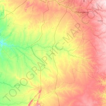
Name: Seke topographic map, elevation, terrain.
Location: Seke, Mashonaland East Province, Zimbabwe (-18.68632 30.69019 -17.92890 31.39344)
Average elevation: 1,360 m
Minimum elevation: 1,197 m
Maximum elevation: 1,558 m
Other topographic maps
Click on a map to view its topography, its elevation and its terrain.
Goromonzi
Zimbabwe > Mashonaland East Province > Goromonzi
Goromonzi, Mashonaland East Province, Zimbabwe
Average elevation: 1,426 m
Bromley
Zimbabwe > Mashonaland East Province > Goromonzi
Bromley, Goromonzi, Mashonaland East Province, Zimbabwe
Average elevation: 1,555 m
Goromonzi
Zimbabwe > Mashonaland East Province
Goromonzi, Mashonaland East Province, Zimbabwe
Average elevation: 1,396 m
Wedza
Zimbabwe > Mashonaland East Province
Wedza, Mashonaland East Province, Zimbabwe
Average elevation: 1,274 m