
Goromonzi topographic map
Interactive map
Click on the map to display elevation.
About this map
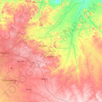
Name: Goromonzi topographic map, elevation, terrain.
Location: Goromonzi, Mashonaland East Province, Zimbabwe (-18.16168 31.08788 -17.47483 31.60868)
Average elevation: 1,396 m
Minimum elevation: 1,077 m
Maximum elevation: 1,692 m
Three medical clinics are available for the community. Resources are strained to serve such a wide area; and some people have to walk 19 kilometres (12 mi) or more to get care. Although malaria is not a serious problem due to Goromonzi’s altitude, schistosomiasis (bilharzia) is widespread and goes untreated along with a multitude of parasitic infections and other easily treated illnesses.
Other topographic maps
Click on a map to view its topography, its elevation and its terrain.
Goromonzi
Zimbabwe > Mashonaland East Province > Goromonzi
Goromonzi, Mashonaland East Province, Zimbabwe
Average elevation: 1,426 m
Bromley
Zimbabwe > Mashonaland East Province > Goromonzi
Bromley, Goromonzi, Mashonaland East Province, Zimbabwe
Average elevation: 1,555 m
Seke
Zimbabwe > Mashonaland East Province
Seke, Mashonaland East Province, Zimbabwe
Average elevation: 1,360 m
Wedza
Zimbabwe > Mashonaland East Province
Wedza, Mashonaland East Province, Zimbabwe
Average elevation: 1,274 m