
Djibouti topographic map
Interactive map
Click on the map to display elevation.
About this map
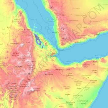
Name: Djibouti topographic map, elevation, terrain.
Location: Djibouti (4.31460 35.34531 19.31460 50.34531)
Average elevation: 816 m
Minimum elevation: -123 m
Maximum elevation: 4,281 m
Other topographic maps
Click on a map to view its topography, its elevation and its terrain.
Ali Sabieh
Ali Sabieh is located in a valley in the southern section of the country. The city is situated in a mountainous area, in an enclosed valley of the highlands. It sits at an elevation of 756 metres (2,480 feet) above sea level. Ali Sabieh is a mountainous and hilly town. This altitude gives the settlement and…
Average elevation: 733 m
Tadjourah
Elevations play a major factor in temperature, with the escarpments and plateaus on average 11 °C (52 °F) cooler, day or night. The climate of the coastal strip is influenced by warm ocean waters, keeping the closest parts free from extremes highs and providing occasional rainfall. The overnight lows in the…
Average elevation: 496 m
Lake Assal
Lake Assal is located in the middle of Djibouti, in a closed depression at the northern end of the Great Rift Valley. Situated in the Danakil Desert, it is bounded by hills on the western region. The lake lies at an elevation of 155 m (509 ft) below sea level, making it the lowest point of Africa. The lake is…
Average elevation: -133 m