
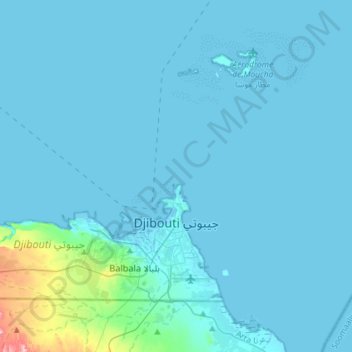
Djibouti topographic map
Interactive map
Click on the map to display elevation.
About this map
Name: Djibouti topographic map, elevation, terrain.
Location: Djibouti (11.52910 42.92425 11.73145 43.21404)
Average elevation: 15 m
Minimum elevation: -5 m
Maximum elevation: 264 m
Other topographic maps
Click on a map to view its topography, its elevation and its terrain.
Ali Sabieh
Ali Sabieh is located in a valley in the southern section of the country. The city is situated in a mountainous area, in an enclosed valley of the highlands. It sits at an elevation of 756 metres (2,480 feet) above sea level. Ali Sabieh is a mountainous and hilly town. This altitude gives the settlement and…
Average elevation: 733 m
Djibouti
Djibouti > Djibouti > Djibouti
Djibouti is situated in the Horn of Africa on the Gulf of Aden and the Bab-el-Mandeb, at the southern entrance to the Red Sea. It lies between latitudes 11° and 14°N and longitudes 41° and 44°E, at the northernmost point of the Great Rift Valley. It is here in Djibouti that the rift between the African…
Average elevation: 36 m
Dikhil
Dikhil has a Semi-arid climate (Köppen climate classification: BSh). Characterized by hot and dry summers, and mild to cool winters where most of the precipitation is concentrated (spring and autumn being pleasantly warm transitional seasons). However, due to the town's altitude and inland location, its…
Average elevation: 521 m
Alaili Dadda`
Djibouti > Obock > Alaili Dadda`
Alaili Dadda` (Arabic: علايلي دادا) is a town in northern Djibouti. It is situated about 68 kilometers north of Obock, at an elevation of 1,263 feet from sea level. The town sprawls on a wide basin surrounded by granitic mountains on all sides. It is located in the Alaili Dadda district of the…
Average elevation: 400 m