
飯島町 topographic map
Interactive map
Click on the map to display elevation.
About this map
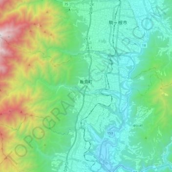
Name: 飯島町 topographic map, elevation, terrain.
Location: 飯島町, 上伊那郡, 長野県, 中部地方, 399-3797, 日本 (35.63501 137.80115 35.71685 137.97866)
Average elevation: 1,035 m
Minimum elevation: 469 m
Maximum elevation: 2,846 m
Other topographic maps
Click on a map to view its topography, its elevation and its terrain.