
Andalusia topographic map
Interactive map
Click on the map to display elevation.
About this map
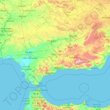
Name: Andalusia topographic map, elevation, terrain.
Location: Andalusia, Spain (35.93764 -7.52269 38.72909 -1.62980)
Average elevation: 378 m
Minimum elevation: -2 m
Maximum elevation: 3,273 m
Andalusia sits at a latitude between 36° and 38° 44' N, in the warm-temperate region. In general, it experiences a hot-summer Mediterranean climate, with dry summers influenced by the Azores High, but subject to occasional torrential rains and extremely hot temperatures. In the winter, the tropical anticyclones move south, allowing cold polar fronts to penetrate the region. Still, within Andalusia there is considerable climatic variety. From the extensive coastal plains one may pass to the valley of the Guadalquivir, barely above sea level, then to the highest altitudes in the Iberian peninsula in the peaks of the Sierra Nevada. In a mere 50 km (31 mi) one can pass from the subtropical coast of the province of Granada to the snowy peaks of Mulhacén. Andalusia also includes both the dry Tabernas Desert in the province of Almería and the Sierra de Grazalema Natural Park in the province of Cádiz, which experiences Spain's greatest rainfall.
Other topographic maps
Click on a map to view its topography, its elevation and its terrain.
Barcelona
Spain > Catalonia > Barcelonès
Barcelona, Barcelonès, Barcelona, Catalonia, 08001, Spain
Average elevation: 65 m
Bianditz
Spain > Navarre > Baztan-Bidasoa > Lesaka
Bianditz, Lesaka, Baztan-Bidasoa, Navarre, Spain
Average elevation: 632 m
Granada
Spain > Andalusia > Comarca de la Vega de Granada
Granada, Comarca de la Vega de Granada, Granada, Andalusia, Spain
Average elevation: 829 m
Planes
Planes, el Comtat, Alacant / Alicante, Valencian Community, Spain
Average elevation: 523 m
Truchas / Trueitas
Spain > Castile and León > Truchas
Truchas / Trueitas, Truchas, León, Castile and León, 24740, Spain
Average elevation: 1,210 m
Málaga
Spain > Andalusia > Málaga-Costa del Sol
Málaga, Málaga-Costa del Sol, Malaga, Andalusia, Spain
Average elevation: 276 m
As Brañas
Spain > Galicia > Betanzos > O Pazo de Irixoa
As Brañas, Mántaras, O Pazo de Irixoa, Irixoa, Betanzos, A Coruña, Galicia, 15313, Spain
Average elevation: 379 m
Alicante
Alicante, l'Alacantí, Alacant / Alicante, Valencian Community, Spain
Average elevation: 143 m
As Brañas
Spain > Galicia > Bergantiños > A Laracha
As Brañas, Torás, A Laracha, Bergantiños, A Coruña, Galicia, 15145, Spain
Average elevation: 176 m
As Brañas
Spain > Galicia > A Mariña Oriental
As Brañas, San Pedro de Benquerencia, Barreiros, A Mariña Oriental, Lugo, Galicia, 27793, Spain
Average elevation: 20 m
Casas del Lomo
Casas del Lomo, Tejeda, Las Palmas, Canary Islands, 35360, Spain
Average elevation: 1,226 m
Iznate
Spain > Andalusia > La Axarquía
Iznate, La Axarquía, Malaga, Andalusia, 29792, Spain
Average elevation: 251 m
Cornudella de Montsant
Cornudella de Montsant, Priorat, Tarragona, Catalonia, 43360, Spain
Average elevation: 700 m
Panticosa
Spain > Aragon > Alto Gállego
Panticosa, Alto Gállego, Huesca, Aragon, Spain
Average elevation: 1,916 m
Veleta
Spain > Castile and León > Valle del Retortillo
Veleta, Valle del Retortillo, Palencia, Castile and León, 34307, Spain
Average elevation: 791 m
Campell
Spain > Valencian Community > Pedreguer
Campell, Pedreguer, la Marina Alta, Alacant / Alicante, Valencian Community, 03750, Spain
Average elevation: 115 m
Ronda
Spain > Andalusia > Serranía de Ronda
Ronda, Serranía de Ronda, Malaga, Andalusia, Spain
Average elevation: 801 m
Trillo
Trillo, Guadalajara, Castile-La Mancha, 19450, Spain
Average elevation: 899 m
Sant Martí
Spain > Catalonia > Barcelonès > Barcelona
Sant Martí, Barcelona, Barcelonès, Barcelona, Catalonia, 08001, Spain
Average elevation: 17 m
Hospital
Spain > Galicia > Os Ancares > Pedrafita do Cebreiro
Hospital, Pedrafita do Cebreiro, Os Ancares, Lugo, Galicia, Spain
Average elevation: 1,184 m
Aldeatejada
Aldeatejada, Salamanca, Castile and León, Spain
Average elevation: 838 m
Vinaròs
Vinaròs, el Baix Maestrat, Castelló / Castellón, Valencian Community, 12500, Spain
Average elevation: 54 m
Vitales
Spain > Aragon > Hoya de Huesca / Plana de Uesca > Monflorite-Lascasas
Vitales, Monflorite-Lascasas, Hoya de Huesca / Plana de Uesca, Aragon, 22112, Spain
Average elevation: 492 m
Navajas
Navajas, l'Alt Palància, Castelló / Castellón, Valencian Community, 12470, Spain
Average elevation: 441 m
la Coma
Spain > Catalonia > Solsonès > la Coma i la Pedra
la Coma, la Coma i la Pedra, Solsonès, Lleida, Catalonia, 25284, Spain
Average elevation: 1,308 m