
Make a donation
Gear up for your next adventure:
As an Amazon Associate, this site earns from qualifying purchases at no extra cost to you.
Sindh topographic map
Click on the map to display elevation.
Make a donation
Gear up for your next adventure:
As an Amazon Associate, this site earns from qualifying purchases at no extra cost to you.
Sindh
There is no evidence of large palaces or large tombs for the elite. The grand and presumably holy site might have been the great bath, which is built upon an artificially created elevation. This civilization collapsed around 1700 BC for reasons that are uncertain; the cause is hotly debated and may have been a massive earthquake, which dried up the Ghaggar River. Skeletons discovered in the ruins of Moan Jo Daro ("mount of dead") were thought to indicate that the city was suddenly attacked and the population was wiped out, but further examinations showed that the marks on the skeletons were due to erosion and not of violence.
Make a donation
Gear up for your next adventure:
As an Amazon Associate, this site earns from qualifying purchases at no extra cost to you.
About this map
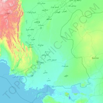
Name: Sindh topographic map, elevation, terrain.
Location: Sindh, Pakistan (23.43420 66.28623 28.49564 71.12577)
Average elevation: 173 m
Minimum elevation: -5 m
Maximum elevation: 2,662 m
Make a donation
Gear up for your next adventure:
As an Amazon Associate, this site earns from qualifying purchases at no extra cost to you.
Other topographic maps
Click on a map to view its topography, its elevation and its terrain.
Islamabad
Pakistan > Islamabad Capital Territory
Islamabad is located at 33°26′N 73°02′E / 33.43°N 73.04°E / 33.43; 73.04 at the northern edge of the Pothohar Plateau and at the foot of the Margalla Hills in Islamabad Capital Territory. Its elevation is 540 metres (1,770 ft). The modern capital and the ancient Gakhar city of Rawalpindi form…
Average elevation: 666 m
Rawalpindi
Pakistan > Punjab > Rawalpindi District > Rawalpindi Cantonment
Rawalpindi features a humid subtropical climate (Köppen: Cwa) with hot and wet summers, a cooler and drier winter. Rawalpindi and its twin city Islamabad, during the year experiences an average of 91 thunderstorms, which is the highest frequency of any plain elevation city in the country. Strong windstorms…
Average elevation: 530 m
K2
Pakistan > Gilgit-Baltistan > Shigar District
K2 is the only 8,000+ metre peak that has never been climbed from its eastern face. Ascents have almost always been made in July and August, which are typically the warmest times of the year; K2's more northern location makes it more susceptible to inclement and colder weather. The peak has now been climbed by…
Average elevation: 7,474 m
Make a donation
Gear up for your next adventure:
As an Amazon Associate, this site earns from qualifying purchases at no extra cost to you.
Murree
Pakistan > Punjab > Murree District
Murree (Punjabi, Urdu: مری) is a mountain resort city, located in the Galyat region of the Pir Panjal Range, within the Muree District of Punjab, Pakistan. It forms the outskirts of the Islamabad-Rawalpindi metropolitan area, and is about 30 km (19 mi) northeast of Islamabad. It has average altitude of…
Average elevation: 1,718 m
Skardu
Pakistan > Gilgit-Baltistan > Skardu District
Skardu (Balti: སྐར་མདོ་་; Urdu: سکردو, romanized: skardū, pronounced [skərduː]) is a city located in Pakistani-administered Gilgit−Baltistan in the disputed Kashmir region. Skardu serves as the capital of Skardu District and the Baltistan Division. It is situated at an average…
Average elevation: 3,423 m
Khyber Pakhtunkhwa
Most precipitation falls as thunderstorms or snow during winter and spring, so that the climate at the lowest elevations is classed as Mediterranean (Csa), continental Mediterranean (Dsa) or semi-arid (BSk). Summers are extremely dry in the north of Chitral district and receive only a little rain in the south…
Average elevation: 2,135 m
Karachi
Pakistan > Sindh > Karachi South District > Saddar Town
Karachi lies very close to a major fault line, where the Indian tectonic plate meets the Arabian tectonic plate. Within the city of Karachi are two small ranges: the Khasa Hills and Mulri Hills, which lie in the northwest and act as a barrier between North Nazimabad and Orangi. Karachi's hills are barren and…
Average elevation: 20 m
Make a donation
Gear up for your next adventure:
As an Amazon Associate, this site earns from qualifying purchases at no extra cost to you.
Quetta
Quetta (/ˈkwɛtə/; Urdu: کوئٹہ; [ˈkweːʈə] (listen); Pashto: کوټه) is the tenth most populous city in Pakistan with a population of over 1.1 million. It is situated in south-west of the country close to the International border with Afghanistan. It is the capital of the province of Balochistan…
Average elevation: 1,968 m
Make a donation
Gear up for your next adventure:
As an Amazon Associate, this site earns from qualifying purchases at no extra cost to you.
Achini Payan
Pakistan > Khyber Pakhtunkhwa > Peshāwar District > Peshawar City Tehsil
Average elevation: 407 m
Make a donation
Gear up for your next adventure:
As an Amazon Associate, this site earns from qualifying purchases at no extra cost to you.
Make a donation
Gear up for your next adventure:
As an Amazon Associate, this site earns from qualifying purchases at no extra cost to you.
Khuzdar
Pakistan > Balochistan > Khuzdar District
Khuzdar is at the apex of a narrow valley at an elevation of 1,237 metres (4,058 ft). Despite this altitude, Khuzdar like most of Balochistan has a semi arid climate (Köppen BSh) with very low and erratic rainfall. Unlike most parts of the province, the heaviest average rainfall comes from the Asian monsoon…
Average elevation: 1,417 m
Hindu Kush
Pakistan > Khyber Pakhtunkhwa > Chitrāl District > Chitral Tehsil
Average elevation: 5,281 m
Make a donation
Gear up for your next adventure:
As an Amazon Associate, this site earns from qualifying purchases at no extra cost to you.
Make a donation
Gear up for your next adventure:
As an Amazon Associate, this site earns from qualifying purchases at no extra cost to you.
Abbottabad
Pakistan > Khyber Pakhtunkhwa > Abbottābād District
Abbottabad (/ˈæbətəbɑːd/; Urdu, Hindko: ایبٹ آباد, romanized: aibṭabād, pronounced [ɛːbʈəˈbaːd̪]) is the capital city of Abbottabad District in the Hazara region of eastern Khyber Pakhtunkhwa, Pakistan. It is the 40th largest city in Pakistan and fourth largest in the province of Khyber…
Average elevation: 1,363 m
Make a donation
Gear up for your next adventure:
As an Amazon Associate, this site earns from qualifying purchases at no extra cost to you.
Rawalakot
Pakistan > Azad Kashmir > Poonch District
Rawalakot is located at Latitude 33°51'32.18"N, Longitude 73° 45'34.93"E and an Elevation of 5374 feet. Rawalakot is approximately 76 kilometres (47 mi) from Kahuta and about 120 km (75 mi) from the city of Rawalpindi, Pakistan. It is linked with Rawalpindi and Islamabad via Goyain Nala and Tain roads. Via…
Average elevation: 1,501 m
Make a donation
Gear up for your next adventure:
As an Amazon Associate, this site earns from qualifying purchases at no extra cost to you.
Islamabad
Pakistan > Islamabad Capital Territory
Islamabad is located at 33°26′N 73°02′E / 33.43°N 73.04°E / 33.43; 73.04 at the northern edge of the Pothohar Plateau and at the foot of the Margalla Hills in Islamabad Capital Territory. Its elevation is 540 metres (1,770 ft). The modern capital and the ancient Gakhar city of Rawalpindi form…
Average elevation: 666 m
Make a donation
Gear up for your next adventure:
As an Amazon Associate, this site earns from qualifying purchases at no extra cost to you.
Gilgit
Pakistan > Gilgit-Baltistan > Gilgit District
Gilgit lacks significant rainfall, averaging in 120 to 240 mm (4.7 to 9.4 in) annually, as monsoon breaks against the southern range of Himalayas. Irrigation for land cultivation is obtained from the rivers, abundant with melting snow water from higher altitudes.
Average elevation: 3,002 m
Make a donation
Gear up for your next adventure:
As an Amazon Associate, this site earns from qualifying purchases at no extra cost to you.
Zhob
Pakistan > Balochistan > Zhob District
Zhob has a semi-arid climate (Köppen BSh). Its rainfall is high enough to avoid the arid climate category found at lower elevations. Zhob receive rainfall on occasions from the monsoon, though this occurs very erratically.
Average elevation: 1,569 m
Make a donation
Gear up for your next adventure:
As an Amazon Associate, this site earns from qualifying purchases at no extra cost to you.
Make a donation
Gear up for your next adventure:
As an Amazon Associate, this site earns from qualifying purchases at no extra cost to you.
Faisalabad
The soil consists of young stratified silt loam or very fine sand loam which makes the subsoil weak in structure with common kankers at only five feet. The course of the rivers within Faisalabad are winding and often subject to frequent alternations. In the rainy season, the currents are very strong. This…
Average elevation: 184 m
Gujranwala
Gujranwala sits at the heart of the Rechna Doab, a strip of land between the Chenab in the north, and Ravi River in the south. Gujranwala is also part of the Majha, a historical region of northern Punjab. The city was built upon the plains of Punjab, and the surrounding region is an unbroken plain devoid of…
Average elevation: 225 m
Nanga Parbat
Pakistan > Gilgit-Baltistan > Astore District
To the south, Nanga Parbat has what is often referred to as the highest mountain face in the world: the Rupal Face rises 4,600 m (15,090 ft) above its base. To the north, the complex, somewhat more gently sloped Rakhiot Flank rises 7,000 m (23,000 ft) from the Indus River valley to the summit in just 25 km (16…
Average elevation: 7,086 m
Make a donation
Gear up for your next adventure:
As an Amazon Associate, this site earns from qualifying purchases at no extra cost to you.
Dera Ismail Khan
Pakistan > Khyber Pakhtunkhwa > Dera Ismail Khan District
D. I Khan is situated at an altitude of 177 metres above sea level.
Average elevation: 177 m
Bumbagh
Pakistan > Khyber Pakhtunkhwa > Chitrāl District > Torkhow-Molkhow Tehsil
Average elevation: 2,056 m
Make a donation
Gear up for your next adventure:
As an Amazon Associate, this site earns from qualifying purchases at no extra cost to you.
Bahawalnagar
In 1904 when Nawab Mohammad Bahawal Khan Abbasi IV, who originally ruled over Bahawalpur State visited Rojhanwali the people asked that with His permission they want to rename the city on the name of Nawab, The Nawab allowed them with pleasure and since then the city is named as Bahawalnagar. With the advent…
Average elevation: 158 m
Make a donation
Gear up for your next adventure:
As an Amazon Associate, this site earns from qualifying purchases at no extra cost to you.
Make a donation
Gear up for your next adventure:
As an Amazon Associate, this site earns from qualifying purchases at no extra cost to you.
K2
Pakistan > Gilgit-Baltistan > Shigar District
Also occasionally known as Mount Godwin-Austen, other nicknames for K2 are The King of Mountains and The Mountaineers' Mountain, as well as The Mountain of Mountains after prominent Italian climber Reinhold Messner titled his book about K2 the same. Although the summit of Everest is at a higher altitude, K2 is…
Average elevation: 7,474 m
Make a donation
Gear up for your next adventure:
As an Amazon Associate, this site earns from qualifying purchases at no extra cost to you.
Chitral
Pakistan > Khyber Pakhtunkhwa > Chitrāl District
The city has an average elevation of 1,500 m (4,921 ft).
Average elevation: 2,982 m
Make a donation
Gear up for your next adventure:
As an Amazon Associate, this site earns from qualifying purchases at no extra cost to you.
Nara Canal
Left Bank Outfall Drain to the west of Nara Canal, built much later (starting in the 1960s and 80s) than Nara Canal, the LBOD was designed to solve the waterlogging and salinity problems caused by intensive irrigation from canals like the Nara. It collects salty groundwater and industrial/agricultural waste…
Average elevation: 37 m
Make a donation
Gear up for your next adventure:
As an Amazon Associate, this site earns from qualifying purchases at no extra cost to you.
Make a donation
Gear up for your next adventure:
As an Amazon Associate, this site earns from qualifying purchases at no extra cost to you.
Gwādar
Gwadar is situated on the southwestern Arabian Sea coast of Pakistan in Gwadar District of Balochistan province. Like Ormara further east, Gwadar is situated on a natural hammerhead-shaped tombolo peninsula forming two almost perfect, but naturally curved, semicircular bays on either side. The city is situated…
Average elevation: 6 m
Mirpur
Pakistan > Azad Kashmir > Mirpur District
Mirpur lies at the foothills of the Himalayas mountain range of an altitude of 648 metres or 2,126 feet above sea level and is linked with the main Peshawar-Lahore Grand Trunk Road at Dina Tehsil. It is the headquarters of Mirpur District, which has two subdivisions: Mirpur and Dudial. Mirpur is now one of the…
Average elevation: 377 m
Make a donation
Gear up for your next adventure:
As an Amazon Associate, this site earns from qualifying purchases at no extra cost to you.
Make a donation
Gear up for your next adventure:
As an Amazon Associate, this site earns from qualifying purchases at no extra cost to you.
K2
Pakistan > Gilgit-Baltistan > Shigar District
Also occasionally known as Mount Godwin-Austen, other nicknames for K2 are The King of Mountains and The Mountaineers' Mountain, as well as The Mountain of Mountains after prominent Italian climber Reinhold Messner titled his book about K2 the same. Although the summit of Everest is at a higher altitude, K2 is…
Average elevation: 7,474 m
Make a donation
Gear up for your next adventure:
As an Amazon Associate, this site earns from qualifying purchases at no extra cost to you.
Mardan
Pakistan > Khyber Pakhtunkhwa > Mardān District
Mardan is located in the south west of the district at 34°12'0N 72°1'60E and an altitude of 283 metres (928 ft). Mardan is a district headquarter of Mardan District of Khyber Pakhtunkhwa. Risalpur is located to the south, Charsadda is located to the west, Yar Hussain to the east and Takht Bahi & Katlang to…
Average elevation: 328 m
Make a donation
Gear up for your next adventure:
As an Amazon Associate, this site earns from qualifying purchases at no extra cost to you.