
Forest of Dean topographic map
Interactive map
Click on the map to display elevation.
About this map
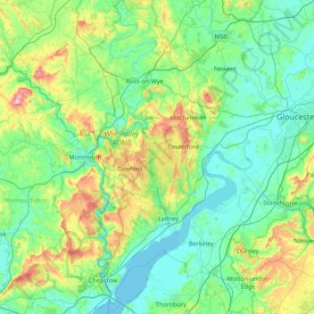
Name: Forest of Dean topographic map, elevation, terrain.
Location: Forest of Dean, Gloucestershire, England, United Kingdom (51.59470 -2.68754 52.02389 -2.26754)
Average elevation: 86 m
Minimum elevation: -2 m
Maximum elevation: 423 m
Gloucestershire trails, hiking, mountain biking, running and outdoor activities
Other topographic maps
Click on a map to view its topography, its elevation and its terrain.
Miserden Estate
United Kingdom > England > Gloucestershire > Stroud > Miserden
Average elevation: 218 m
Little Haresfield
United Kingdom > England > Gloucestershire > Stroud > Standish
Average elevation: 43 m
Wood Stanway
United Kingdom > England > Gloucestershire > Tewkesbury > Stanway
Average elevation: 171 m
River Frome
United Kingdom > England > Gloucestershire > Stroud > Chalford > Chalford Hill
Average elevation: 163 m
Lower Soudley
United Kingdom > England > Gloucestershire > Forest of Dean > Upper Soudley
Average elevation: 119 m
Speech House Lake
United Kingdom > England > Gloucestershire > Forest of Dean
Average elevation: 148 m
Poolway
United Kingdom > England > Gloucestershire > Forest of Dean > Coleford
Average elevation: 197 m
Bakers Hill
United Kingdom > England > Gloucestershire > Forest of Dean > Broadwell
Average elevation: 195 m
Barnwood Park & Arboretum
United Kingdom > England > Gloucestershire > Gloucester
Average elevation: 32 m
Saunders Green
United Kingdom > England > Gloucestershire > Forest of Dean > Whitecroft
Average elevation: 111 m
Bamfurlong
United Kingdom > England > Gloucestershire > Tewkesbury > Staverton
Average elevation: 34 m
Shipton Oliffe
United Kingdom > England > Gloucestershire > Cotswold District > Shipton
Average elevation: 201 m
Brand Green
United Kingdom > England > Gloucestershire > Forest of Dean > Pauntley
Average elevation: 47 m
Jubilee Playing Field & Athletics Track
United Kingdom > England > Gloucestershire > Stroud > Cam > Draycott
Average elevation: 45 m
Calcot
United Kingdom > England > Gloucestershire > Cotswold District > Coln Rogers
Average elevation: 151 m
Grange Village
United Kingdom > England > Gloucestershire > Forest of Dean > Littledean
Average elevation: 98 m
Highbury
United Kingdom > England > Gloucestershire > Forest of Dean > Lydney > Allaston
Average elevation: 65 m
Bream Meend
United Kingdom > England > Gloucestershire > Forest of Dean > Bream
Average elevation: 140 m
Coopers Hill Wood
United Kingdom > England > Gloucestershire > Tewkesbury > Cooper's Hill
Average elevation: 157 m
Lower Slaughter
United Kingdom > England > Gloucestershire > Cotswold District
Average elevation: 160 m
Duntisbourne Abbots
United Kingdom > England > Gloucestershire > Cotswold District
Average elevation: 204 m
Hope Valley
United Kingdom > England > Gloucestershire > Forest of Dean > Lydney > Aylburton
Average elevation: 61 m
Joyford
United Kingdom > England > Gloucestershire > Forest of Dean > Berry Hill
Average elevation: 188 m