
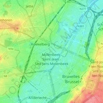
Molenbeek-Saint-Jean - Sint-Jans-Molenbeek topographic map
Interactive map
Click on the map to display elevation.
About this map
Name: Molenbeek-Saint-Jean - Sint-Jans-Molenbeek topographic map, elevation, terrain.
Average elevation: 36 m
Minimum elevation: 10 m
Maximum elevation: 86 m
Other topographic maps
Click on a map to view its topography, its elevation and its terrain.
Brussels
Brussels lies in the north-central part of Belgium, about 110 kilometres (68 mi) from the Belgian coast and about 180 km (110 mi) from Belgium's southern tip. It is located in the heartland of the Brabantian Plateau, about 45 km (28 mi) south of Antwerp (Flanders), and 50 km (31 mi) north of Charleroi…
Average elevation: 54 m
Boitsfort - Bosvoorde
Belgium > Brussels-Capital > Watermael-Boitsfort - Watermaal-Bosvoorde
Average elevation: 96 m
Parc de Laeken - Park van Laken
Belgium > Brussels-Capital > Brussels > Laeken - Laken
Average elevation: 47 m
Molenbeek-Saint-Jean - Sint-Jans-Molenbeek
Belgium > Brussels-Capital > Molenbeek-Saint-Jean - Sint-Jans-Molenbeek
Average elevation: 47 m