
Make a donation
Gear up for your next adventure:
As an Amazon Associate, this site earns from qualifying purchases at no extra cost to you.
Tiber topographic map
Click on the map to display elevation.
Make a donation
Gear up for your next adventure:
As an Amazon Associate, this site earns from qualifying purchases at no extra cost to you.
About this map
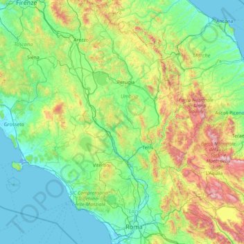
Name: Tiber topographic map, elevation, terrain.
Location: Tiber, Italy (41.74515 12.02487 43.78924 12.63874)
Average elevation: 418 m
Minimum elevation: -5 m
Maximum elevation: 2,720 m
Make a donation
Gear up for your next adventure:
As an Amazon Associate, this site earns from qualifying purchases at no extra cost to you.
Other topographic maps
Click on a map to view its topography, its elevation and its terrain.
Oberglaning - Cologna di Sopra
Italy > Trentino-Alto Adige/Südtirol > South Tyrol > Jenesien - San Genesio Atesino
Average elevation: 844 m
Rome
Italy > Lazio > Roma Capitale
Although the city centre is about 24 km (15 mi) inland from the Tyrrhenian Sea, the city territory extends to the shore, where the south-western district of Ostia is located. The altitude of the central part of Rome ranges from 13 m (43 ft) above sea level (at the base of the Pantheon) to 139 m (456 ft) above…
Average elevation: 78 m
Make a donation
Gear up for your next adventure:
As an Amazon Associate, this site earns from qualifying purchases at no extra cost to you.
Make a donation
Gear up for your next adventure:
As an Amazon Associate, this site earns from qualifying purchases at no extra cost to you.
Piz Boè
Italy > Trentino – Alto Adige/Südtirol > South Tyrol > Corvara in Badia - Corvara
Piz Boè is the highest mountain of the Sella group, a mountain range in the Dolomites, Italy. It has an elevation of 3,152 metres (10,341 ft).
Average elevation: 2,664 m
Make a donation
Gear up for your next adventure:
As an Amazon Associate, this site earns from qualifying purchases at no extra cost to you.
Seiser Alm-Gruppe - Gruppo Mont de Sëuc - Gruppo dell'Alpe di Siusi
Italy > Trentino – Alto Adige/Südtirol > South Tyrol > Kastelruth - Castelrotto
Seiser Alm (Italian: Alpe di Siusi, Ladin: Mont Sëuc) is a Dolomite plateau and the largest high-elevation Alpine meadow (German: Alm) in Europe. Located in Italy's South Tyrol province in the Dolomites mountain range, it is a major tourist attraction, notably for skiing and hiking.
Average elevation: 1,466 m
Passo dello Stelvio
Italy > Trentino-Alto Adige/Südtirol > South Tyrol > Stilfs - Stelvio
The Stelvio Pass (Italian: Passo dello Stelvio [passo ˈdello ˈstɛlvjo], Giogo dello Stelvio [dʒɔgo ˈdello ˈstɛlvjo]; German: Stilfser Joch; [ˈʃtɪlfsɐ jɔx]) is a mountain pass in northern Italy bordering Switzerland at an elevation of 2,757 m (9,045 ft) above sea level. It is the highest paved…
Average elevation: 2,724 m
Make a donation
Gear up for your next adventure:
As an Amazon Associate, this site earns from qualifying purchases at no extra cost to you.
Cesi
Italy > Umbria > Terni > Terni
Cesi is a frazione of the Italian comune of Terni, in the province of Terni, southern Umbria, Italy. The small borgo, which retains its late-medieval aspect, set among olive groves, lies "stretched out lengthwise along a narrow contour on the slopes of M. Torre Maggiore," about 18 km north of Terni at an…
Average elevation: 447 m
Make a donation
Gear up for your next adventure:
As an Amazon Associate, this site earns from qualifying purchases at no extra cost to you.
Make a donation
Gear up for your next adventure:
As an Amazon Associate, this site earns from qualifying purchases at no extra cost to you.
Sardagna
Italy > Trentino – Alto Adige/Südtirol > Provincia di Trento > Trento
Average elevation: 579 m
Gnates
Italy > Trentino – Alto Adige/Südtirol > South Tyrol > La Val - Wengen - La Valle
Average elevation: 1,504 m
Make a donation
Gear up for your next adventure:
As an Amazon Associate, this site earns from qualifying purchases at no extra cost to you.
Make a donation
Gear up for your next adventure:
As an Amazon Associate, this site earns from qualifying purchases at no extra cost to you.
Dolina Seghina / Šeginov Dol
Italy > Friuli-Venezia Giulia > Trieste > Gabrovizza / Gabrovec > Stazione di Prosecco / Proseška Postaja
Average elevation: 249 m
Make a donation
Gear up for your next adventure:
As an Amazon Associate, this site earns from qualifying purchases at no extra cost to you.
St. Zyprian - San Cipriano
Italy > Trentino-Alto Adige/Südtirol > South Tyrol
Average elevation: 1,454 m
Make a donation
Gear up for your next adventure:
As an Amazon Associate, this site earns from qualifying purchases at no extra cost to you.
Gisse
Italy > Trentino – Alto Adige/Südtirol > South Tyrol > Ahrntal - Valle Aurina
Average elevation: 1,368 m
Make a donation
Gear up for your next adventure:
As an Amazon Associate, this site earns from qualifying purchases at no extra cost to you.
Monte Solaro
Italy > Campania > Naples > Anacapri
Monte Solaro is a mountain on the island of Capri in Campania, Italy. With an elevation of 589 m, its peak is the highest point of Capri.
Average elevation: 155 m
Make a donation
Gear up for your next adventure:
As an Amazon Associate, this site earns from qualifying purchases at no extra cost to you.
Tuenno
Italy > Trentino – Alto Adige/Südtirol > Provincia di Trento > Ville d'Anaunia
Average elevation: 744 m
Make a donation
Gear up for your next adventure:
As an Amazon Associate, this site earns from qualifying purchases at no extra cost to you.
Ghiacciaio del Belvedere
Italy > Piedmont > Verbano-Cusio-Ossola > Macugnaga
Average elevation: 2,211 m
Meransen - Maranza
Italy > Trentino – Alto Adige/Südtirol > South Tyrol
Meransen (Italian: Maranza) is a village in South Tyrol, Italy, in the Mühlbach municipality between Pustertal and Eisacktal. It located on the slopes of the Gitschberg mountain at an altitude of 1,414 m (4,639 ft).
Average elevation: 1,279 m
Make a donation
Gear up for your next adventure:
As an Amazon Associate, this site earns from qualifying purchases at no extra cost to you.
Chiugiana
Italy > Umbria > Perugia > Corciano
Chiugiana-La Commenda is a frazione of the comune of Corciano in the Province of Perugia, Umbria, central Italy. It stands at an elevation of 284 metres (932 ft) above sea level. At the time of the Istat census of 2001 it had 6427 inhabitants.
Average elevation: 315 m
Make a donation
Gear up for your next adventure:
As an Amazon Associate, this site earns from qualifying purchases at no extra cost to you.
Make a donation
Gear up for your next adventure:
As an Amazon Associate, this site earns from qualifying purchases at no extra cost to you.
Make a donation
Gear up for your next adventure:
As an Amazon Associate, this site earns from qualifying purchases at no extra cost to you.
Make a donation
Gear up for your next adventure:
As an Amazon Associate, this site earns from qualifying purchases at no extra cost to you.
Make a donation
Gear up for your next adventure:
As an Amazon Associate, this site earns from qualifying purchases at no extra cost to you.
Make a donation
Gear up for your next adventure:
As an Amazon Associate, this site earns from qualifying purchases at no extra cost to you.
Make a donation
Gear up for your next adventure:
As an Amazon Associate, this site earns from qualifying purchases at no extra cost to you.
Mount Etna
Italy > Sicily > Maletto > Adrano
During the first 1500 years AD, many eruptions went unrecorded (or records have been lost); among the more significant are: (1) an eruption in about 1030 AD near Monte Ilice on the lower southeast flank, which produced a lava flow that travelled about 10 km, reaching the sea north of Acireale; the villages of…
Average elevation: 1,157 m
Make a donation
Gear up for your next adventure:
As an Amazon Associate, this site earns from qualifying purchases at no extra cost to you.
Fiume Brenta
Italy > Trentino-Alto Adige/Südtirol > Provincia di Trento > Caldonazzo > Brenta
Average elevation: 470 m
Make a donation
Gear up for your next adventure:
As an Amazon Associate, this site earns from qualifying purchases at no extra cost to you.
Make a donation
Gear up for your next adventure:
As an Amazon Associate, this site earns from qualifying purchases at no extra cost to you.
Make a donation
Gear up for your next adventure:
As an Amazon Associate, this site earns from qualifying purchases at no extra cost to you.