
Tokai topographic map
Interactive map
Click on the map to display elevation.
About this map
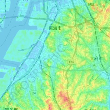
Name: Tokai topographic map, elevation, terrain.
Location: Tokai, Aichi Prefecture, Chubu Region, 477-0032, Japan (34.96955 136.83791 35.06893 136.94035)
Average elevation: 16 m
Minimum elevation: -9 m
Maximum elevation: 70 m
Tōkai is located in the far northwestern neck of Chita Peninsula in southern Aichi Prefecture, and is bordered by Ise Bay to the east, and the metropolis of Nagoya to the north. It extends 8.06 kilometers from east to west and 10.97 kilometers from north to south. Much of the city is near sea level in altitude.
Other topographic maps
Click on a map to view its topography, its elevation and its terrain.
Mount Fuji
Japan > Sunto County > Oyama
Mount Fuji, Oyama, Sunto County, Shizuoka Prefecture, Chubu Region, Japan
Average elevation: 3,261 m
Observation Deck (North Terminal)
Observation Deck (North Terminal), Osakaden, Itami, Hyogo Prefecture, Japan
Average elevation: 21 m
Lake Ashi
Japan > Ashigarashimo County > Hakone
Lake Ashi, Hakone, Ashigarashimo County, Kanagawa Prefecture, Japan
Average elevation: 869 m
Nishi Mera
Nishi Mera, Koyu County, Miyazaki Prefecture, Japan
Average elevation: 656 m
Maborikaigan 4-chome Park
Maborikaigan 4-chome Park, Maboricho 3-chome, Yokosuka, Kanagawa Prefecture, 238-8550, Japan
Average elevation: 22 m
Ibaraki
Ibaraki, Higashiibaraki County, Ibaraki Prefecture, 311-3116, Japan
Average elevation: 26 m
Lake Sanaru
Lake Sanaru, Hamamatsu, Shizuoka Prefecture, Chubu Region, Japan
Average elevation: 16 m
Motoyama
Motoyama, Nagaoka County, Kochi Prefecture, 781-3601, Japan
Average elevation: 679 m
Setouchi
Setouchi, Oshima County, Kagoshima Prefecture, Japan
Average elevation: 26 m
Higashishirakawa
Higashishirakawa, Kamo County, Gifu Prefecture, Chubu Region, 509-1392, Japan
Average elevation: 658 m