
Sosa topographic map
Interactive map
Click on the map to display elevation.
Sosa
Sōsa is located in far northeastern Chiba Prefecture. It is bordered to the north by the Pacific Ocean on the southwest. The land is mostly flat, and much is from 40 to 50 meters above sea level in average elevation.
About this map
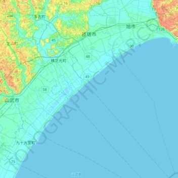
Name: Sosa topographic map, elevation, terrain.
Location: Sosa, Chiba Prefecture, Japan (35.47779 140.48621 35.76116 140.73285)
Average elevation: 7 m
Minimum elevation: -1 m
Maximum elevation: 74 m
Other topographic maps
Click on a map to view its topography, its elevation and its terrain.
Tokyo
The mainland portion of Tokyo lies northwest of Tokyo Bay and measures about 90 km (56 mi) east to west and 25 km (16 mi) north to south. The average elevation in Tokyo is 40 m (131 ft). Chiba Prefecture borders it to the east, Yamanashi to the west, Kanagawa to the south, and Saitama to the north. Mainland…
Average elevation: 22 m
Okinawa Island
The Motobu Peninsula in the north has limestone layers and karst development. In the center and south is mainly a Ryukyu limestone layer and mudstone. The topography is flat, there are few hills over 100 m (328 ft) with very few rivers. The subtropical rains accelerate erosion so there are many drainages and…
Average elevation: 14 m
Hokkaido
Japan's coldest region, Hokkaido has relatively cool summers and icy/snowy winters. Most of the island falls in the humid continental climate zone with Köppen climate classification Dfb (hemiboreal) in most areas but Dfa (hot summer humid continental) in some inland lowlands. The average August temperature…
Average elevation: 98 m
Mt. Fuji
Japan > Sunto County > Oyama
Mount Fuji (富士山, Fujisan, Japanese: [ɸɯꜜ(d)ʑisaɴ] (listen)), or Fugaku, located on the island of Honshū, is the highest mountain in Japan, with a summit elevation of 3,776.24 m (12,389 ft 3 in). It is the second-highest volcano located on an island in Asia (after Mount Kerinci on the island of…
Average elevation: 3,261 m
Yokohama
Yokohama has a total area of 437.38 km2 (168.87 sq mi) at an elevation of 5 metres (16 ft) above sea level. It is the capital of Kanagawa Prefecture, bordered to the east by Tokyo Bay and located in the middle of the Kantō plain. The city is surrounded by hills and the characteristic mountain system of the…
Average elevation: 23 m
Nagato
Nagato is located in northwestern Yamaguchi. The north side faces the Sea of Japan, and the coastline facing the open sea is eroded terrain. On the other hand, there are coves such as Fukagawa Bay and Senzaki Bay, which are surrounded by the island of Ōmijima and the mainland, and Aburaya Bay, which is…
Average elevation: 71 m
Sendai
Sendai is located at lat. 38°16'05" north, long. 140°52'11" east. The city's area is 788.09 km2 (304.28 sq mi), and stretches from the Pacific Ocean to the Ōu Mountains, which are the east and west borders of Miyagi Prefecture. As a result, the city's geography is quite diverse. Eastern Sendai is a plains…
Average elevation: 185 m
Hokkaido Prefecture
As Japan's coldest region, Hokkaidō has relatively cool summers and icy/snowy winters. Most of the island falls in the humid continental climate zone with Köppen climate classification Dfb (hemiboreal) in most areas but Dfa (hot summer humid continental) in some inland lowlands. The average August…
Average elevation: 81 m
Takeo
Takeo is located in the western part of Saga Prefecture. It is approximately 28 kilometers (17 mi) west of Saga City and approximately 30 kilometers (19 mi) east of Sasebo. Takeo has a complex topography including mountains, mountain basins and riverside plains. The population is concentrated in the western…
Average elevation: 103 m
KIta Hiroshima
Kitahiroshima is in the Chūgoku Mountains of north-central Hiroshima, bordered by Shimane Prefecture to the north. Due to its location and elevation, it is a heavy snowfall region.
Average elevation: 424 m
Kanagawa Prefecture
Topographically, the prefecture consists of three distinct areas. The mountainous western region features the Tanzawa Mountain Range and the volcano Mount Hakone. The hilly eastern region is characterized by the Tama Hills and Miura Peninsula. The central region, which surrounds the Tama Hills and Miura…
Average elevation: 170 m
Izenajima
The total area is 15.44 square kilometres (5.96 sq mi), and the peripheral sea coast line is 16 kilometres (9.9 mi). The island's topography features a series of mountains spanning from the northwest to the southeast of the island, with generally flat, arable land covering the remainder. The island has several…
Average elevation: 13 m
Yakushima
The bedrock of the island is granite, and as such it hosts no active volcanoes. It has an area of approximately 504.5 square kilometres (194.8 sq mi). The island is roughly circular in shape, with a circumference of 89 kilometres (55 mi) and a diameter of 28 kilometres (17 mi). The highest elevations on the…
Average elevation: 401 m