
Kyushu topographic map
Interactive map
Click on the map to display elevation.
About this map
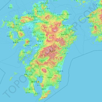
Name: Kyushu topographic map, elevation, terrain.
Location: Kyushu, Japan (30.99427 129.55263 33.96988 132.08533)
Average elevation: 116 m
Minimum elevation: -4 m
Maximum elevation: 1,741 m
The total area is 36,782.37 km2 (14,201.75 sq mi) which makes it the 37th largest island in the world. It's slightly larger than Taiwan island 35,808 km2 (13,826 sq mi). The highest elevation is 1791 meters (5876 feet) on Mount Kujū.
Other topographic maps
Click on a map to view its topography, its elevation and its terrain.
Maborikaigan 4-chome Park
Maborikaigan 4-chome Park, Maboricho 3-chome, Yokosuka, Kanagawa Prefecture, 238-8550, Japan
Average elevation: 22 m
Mount Fuji
Japan > Sunto County > Oyama
Mount Fuji, Oyama, Sunto County, Shizuoka Prefecture, Chubu Region, Japan
Average elevation: 3,261 m
Lake Sanaru
Lake Sanaru, Hamamatsu, Shizuoka Prefecture, Chubu Region, Japan
Average elevation: 16 m
Motoyama
Motoyama, Nagaoka County, Kochi Prefecture, 781-3601, Japan
Average elevation: 679 m
Setouchi
Setouchi, Oshima County, Kagoshima Prefecture, Japan
Average elevation: 26 m
Higashishirakawa
Higashishirakawa, Kamo County, Gifu Prefecture, Chubu Region, 509-1392, Japan
Average elevation: 658 m
Nishikigaoka-chuo Park
Nishikigaoka-chuo Park, Nishikigaoka 2-chome, Aoba Ward, Sendai, Miyagi Prefecture, Japan
Average elevation: 197 m
Katsura Imperial Villa
Katsura Imperial Villa, Road No. 142, Katsura-Kasugacho, Nishikyo Ward, Kyoto, Kyoto Prefecture, 615-8013, Japan
Average elevation: 25 m