
Rioja topographic map
Interactive map
Click on the map to display elevation.
About this map
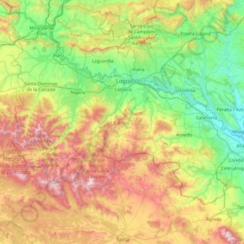
Name: Rioja topographic map, elevation, terrain.
Location: Rioja, Spain (41.91903 -3.13427 42.64426 -1.67870)
Average elevation: 873 m
Minimum elevation: 269 m
Maximum elevation: 2,298 m
The mountains in La Rioja are part of the Iberian System. This mountain range extends to the south of the Ebro river, parallel to it at a distance of about 40 to 60 km (25 to 37 miles), with altitudes ranging between 1,000 and 2,000 m (3,300 and 6,600 feet). From the mountain range the Sierra de la Demanda runs northwards, into the heart of La Rioja, incorporating Monte San Lorenzo which, at 2,271 m (7,451 ft), is the highest peak in the province. Other mountains include Sierra de Camero Viejo, Sierra de Camero Nuevo, Sierra de Cebollera, and Picos de Urbión.
Other topographic maps
Click on a map to view its topography, its elevation and its terrain.
Bianditz
Spain > Navarre > Baztan-Bidasoa > Lesaka
Bianditz, Lesaka, Baztan-Bidasoa, Navarre, Spain
Average elevation: 632 m
Barcelona
Spain > Catalonia > Barcelonès
Barcelona, Barcelonès, Barcelona, Catalonia, 08001, Spain
Average elevation: 65 m
Granada
Spain > Andalusia > Comarca de la Vega de Granada
Granada, Comarca de la Vega de Granada, Granada, Andalusia, Spain
Average elevation: 829 m
Planes
Planes, el Comtat, Alacant / Alicante, Valencian Community, Spain
Average elevation: 523 m
Truchas / Trueitas
Spain > Castile and León > Truchas
Truchas / Trueitas, Truchas, León, Castile and León, 24740, Spain
Average elevation: 1,210 m
Málaga
Spain > Andalusia > Málaga-Costa del Sol
Málaga, Málaga-Costa del Sol, Malaga, Andalusia, Spain
Average elevation: 276 m
As Brañas
Spain > Galicia > Betanzos > O Pazo de Irixoa
As Brañas, Mántaras, O Pazo de Irixoa, Irixoa, Betanzos, A Coruña, Galicia, 15313, Spain
Average elevation: 379 m
Alicante
Alicante, l'Alacantí, Alacant / Alicante, Valencian Community, Spain
Average elevation: 143 m
As Brañas
Spain > Galicia > Bergantiños > A Laracha
As Brañas, Torás, A Laracha, Bergantiños, A Coruña, Galicia, 15145, Spain
Average elevation: 176 m
As Brañas
Spain > Galicia > A Mariña Oriental
As Brañas, San Pedro de Benquerencia, Barreiros, A Mariña Oriental, Lugo, Galicia, 27793, Spain
Average elevation: 20 m
Casas del Lomo
Casas del Lomo, Tejeda, Las Palmas, Canary Islands, 35360, Spain
Average elevation: 1,226 m
Iznate
Spain > Andalusia > La Axarquía
Iznate, La Axarquía, Malaga, Andalusia, 29792, Spain
Average elevation: 251 m
Cornudella de Montsant
Cornudella de Montsant, Priorat, Tarragona, Catalonia, 43360, Spain
Average elevation: 700 m
Panticosa
Spain > Aragon > Alto Gállego
Panticosa, Alto Gállego, Huesca, Aragon, Spain
Average elevation: 1,916 m
Veleta
Spain > Castile and León > Valle del Retortillo
Veleta, Valle del Retortillo, Palencia, Castile and León, 34307, Spain
Average elevation: 791 m
Campell
Spain > Valencian Community > Pedreguer
Campell, Pedreguer, la Marina Alta, Alacant / Alicante, Valencian Community, 03750, Spain
Average elevation: 115 m
Ronda
Spain > Andalusia > Serranía de Ronda
Ronda, Serranía de Ronda, Malaga, Andalusia, Spain
Average elevation: 801 m
Trillo
Trillo, Guadalajara, Castile-La Mancha, 19450, Spain
Average elevation: 899 m
Sant Martí
Spain > Catalonia > Barcelonès > Barcelona
Sant Martí, Barcelona, Barcelonès, Barcelona, Catalonia, 08001, Spain
Average elevation: 17 m
Hospital
Spain > Galicia > Os Ancares > Pedrafita do Cebreiro
Hospital, Pedrafita do Cebreiro, Os Ancares, Lugo, Galicia, Spain
Average elevation: 1,184 m
Aldeatejada
Aldeatejada, Salamanca, Castile and León, Spain
Average elevation: 838 m
Vinaròs
Vinaròs, el Baix Maestrat, Castelló / Castellón, Valencian Community, 12500, Spain
Average elevation: 54 m