
b29 topographic map
Interactive map
Click on the map to display elevation.
About this map
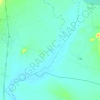
Name: b29 topographic map, elevation, terrain.
Location: b29, Sanmatenga, Central-North, Burkina Faso (12.97778 -1.08919 13.01778 -1.04919)
Average elevation: 298 m
Minimum elevation: 289 m
Maximum elevation: 330 m
Other topographic maps
Click on a map to view its topography, its elevation and its terrain.
Sahel
The topography of the Sahel is mainly flat; most of the region lies between 200 and 400 meters (660 and 1,310 ft) in elevation. Several isolated plateaus and mountain ranges rise from the Sahel, but are designated as separate ecoregions because their flora and fauna are distinct from the surrounding lowlands.…
Average elevation: 279 m
Upper-Basins
Most of Burkino Faso is a wide plateau formed by riverine systems and is called falaise de Banfora. There are three major rivers, the Red Volta, Black Volta and White Volta, which cuts through different valleys. The climate is generally hot, with unreliable rains across different seasons. Gold and quartz are…
Average elevation: 330 m
North
Most of Burkino Faso is a wide plateau formed by riverine systems and is called falaise de Banfora. There are three major rivers, the Red Volta, Black Volta and White Volta, which cuts through different valleys. The climate is generally hot, with unreliable rains across different seasons. Gold and quartz are…
Average elevation: 311 m
Sahel
The topography of the Sahel is mainly flat; most of the region lies between 200 and 400 meters (660 and 1,310 ft) in elevation. Several isolated plateaus and mountain ranges rise from the Sahel, but are designated as separate ecoregions because their flora and fauna are distinct from the surrounding lowlands.…
Average elevation: 294 m