Basque Country topographic map
Click on the map to display elevation.
Basque Country
The Basque Country region is dominated by a warm, humid and wet oceanic climate. The coastal area is part of Green Spain and by extension, the climate is similary for Bayonne and Biarritz as well. Inland areas in Navarre and the southern regions of the autonomous community are transitional, with continental mediterranean climate, with somewhat wider temperature swings between seasons. The list only sources locations in Spain, but Bayonne/Biarritz have a very similar climate to nearby Hondarribia on the Spanish side of the border. The values do not apply to San Sebastián, since its weather station is at a higher elevation than the urban core, where temperatures are higher year-round and similar to those in Bilbao and Hondarribia.
About this map
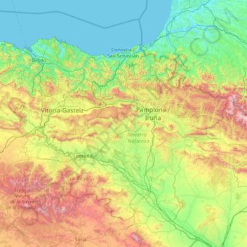
Name: Basque Country topographic map, elevation, terrain.
Location: Basque Country, Spain (41.90989 -3.45091 43.54743 -0.65272)
Average elevation: 560 m
Minimum elevation: -2 m
Maximum elevation: 2,626 m
Other topographic maps
Click on a map to view its topography, its elevation and its terrain.

Picos de Europa
The Picos de Europa ("Peaks of Europe", also the Picos) are a mountain range extending for about 20 km (12 mi), forming part of the Cantabrian Mountains in northern Spain. The range is situated in the Autonomous Communities of Asturias, Cantabria and Castile and León. The highest peak is Torre de Cerredo, at…
Average elevation: 2,290 m
Pyrenees
The Pyrenees (/ˈpɪrɪniːz/; Spanish: Pirineos [piɾiˈneos]; French: Pyrénées [piʁene] (listen); Catalan: Pirineu [piɾiˈnɛw]; Basque: Pirinioak [piɾini.o.ak]; Occitan: Pirenèus [piɾeˈnɛws]; Aragonese: Pirineus) is a mountain range straddling the border of France and Spain. It extends nearly 500…
Average elevation: 491 m

Pyrenees
The Pyrenees is a mountain range in southwestern Europe, straddling the France–Spain border. The Pyrenees extend nearly 500 kilometres (310 mi) from their union with the Cantabrian Mountains to Cap de Creus on the Mediterranean coast, reaching a maximum elevation of 3,404 metres (11,168 ft) at the peak of…
Average elevation: 570 m

La Marina
Spain > Valencian Community > el Baix Segura / La Vega Baja > Guardamar del Segura
Average elevation: 7 m



Serra d'Aitana
Spain > Valencian Community > la Marina Baixa > Benifato
The most spectacular part of the trail is the Font de Partagás - Pas de la rabossa - Summit of Aitana with a distance of 2 km. It starts at 1040 meters elevation, with almost 500 meters of uneven terrain. The path is well signposted with trail markings and distance signs.
Average elevation: 836 m

Vigo
Vigo has a transitional climate between the oceanic climate "Cfb" and the warm-summer Mediterranean climate "Csb" according to the Köppen climate classification. Although Vigo is the rainiest city in Galicia, with its noticeable drying trend in the summer, Vigo's climate is more similar to the variant of the…
Average elevation: 121 m






Pyrenees
The Pyrenees (/ˈpɪrɪniːz/; Spanish: Pirineos [piɾiˈneos]; French: Pyrénées [piʁene] (listen); Catalan: Pirineu [piɾiˈnɛw]; Basque: Pirinioak [piɾini.o.ak]; Occitan: Pirenèus [piɾeˈnɛws]; Aragonese: Pirineus) is a mountain range straddling the border of France and Spain. It extends nearly 500…
Average elevation: 491 m


Cerro de la Florosa
Spain > Andalusia > Comarca de la Costa Granadina > Los Guájares
Average elevation: 922 m
Alhambra
Spain > Andalusia > Comarca de la Vega de Granada > Granada
During the reign of the Nasrid Dynasty, the Alhambra was transformed into a palatine city, complete with an irrigation system composed of aqueducts and water channels that provided water for the complex and for other nearby countryside palaces such as the Generalife. Previously, the old fortresses on the hill…
Average elevation: 759 m


Santiago de Compostela
The cathedral borders the main plaza of the old and well-preserved city. According to medieval legend, the remains of the apostle James were brought to Galicia for burial; in 813, the light of a bright star guided a shepherd who was watching his flock at night to the burial site in Santiago de Compostela. This…
Average elevation: 248 m

Picos de Europa
The Picos de Europa ("Peaks of Europe", also the Picos) are a mountain range extending for about 20 km (12 mi), forming part of the Cantabrian Mountains in northern Spain. The range is situated in the Autonomous Communities of Asturias, Cantabria and Castile and León. The highest peak is Torre de Cerredo, at…
Average elevation: 2,290 m

San Nicolás Viewpoint
Spain > Andalusia > Comarca de la Vega de Granada > Granada
Average elevation: 760 m


Parque Municipal Villafranco del Guadiana
Spain > Extremadura > Badajoz > Villafranco del Guadiana
Average elevation: 185 m






Soportújar
Spain > Andalusia > Comarca de la Alpujarra Granadina > Soportújar
Average elevation: 1,048 m












Teide
Spain > Canary Islands > La Orotava
Teide, or Mount Teide, (Spanish: El Teide, Pico del Teide, pronounced [ˈpiko ðel ˈtejðe], "Peak of Teide") is a volcano on Tenerife in the Canary Islands, Spain. Its summit (at 3,715 m (12,188 ft)) is the highest point in Spain and the highest point above sea level in the islands of the Atlantic. If…
Average elevation: 3,200 m


Vitoria-Gasteiz
Spain > Autonomous Community of the Basque Country > Gasteizko kuadrilla
Vitoria-Gasteiz has an oceanic climate (Köppen climate classification: Cfb). Winters are much cooler than in lowland coastal areas, whilst summers are similar in terms of high temperatures, with cool nights due to the elevation. Summers show a significant influence of mediterranean precipitation patterns, but…
Average elevation: 655 m