
Make a donation
Gear up for your next adventure:
As an Amazon Associate, this site earns from qualifying purchases at no extra cost to you.
Morris County topographic map
Click on the map to display elevation.
Make a donation
Gear up for your next adventure:
As an Amazon Associate, this site earns from qualifying purchases at no extra cost to you.
Morris County
The county rises in elevation and relief from east to west, with only the more developed eastern suburbs in the Passaic River valley being relatively level. The highest point is at 1,395 feet (425 m) above sea level on a mountain south of Pine Swamp in western Jefferson Township. The second-highest point is on a mountain just north of Riker Lake at 1,358 feet (414 m). The lowest point is about 160 feet (49 m) in elevation, at Two Bridges, the confluence of the Passaic and Pompton rivers.
Make a donation
Gear up for your next adventure:
As an Amazon Associate, this site earns from qualifying purchases at no extra cost to you.
About this map
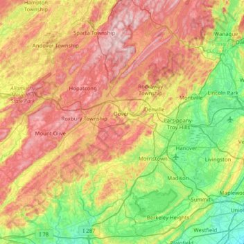
Name: Morris County topographic map, elevation, terrain.
Location: Morris County, New Jersey, United States (40.64952 -74.88877 41.08600 -74.26664)
Average elevation: 182 m
Minimum elevation: 9 m
Maximum elevation: 426 m
Make a donation
Gear up for your next adventure:
As an Amazon Associate, this site earns from qualifying purchases at no extra cost to you.
Other topographic maps
Click on a map to view its topography, its elevation and its terrain.
Basking Ridge
United States > New Jersey > Somerset County > Bernards Township
Average elevation: 98 m
Croxton
United States > New Jersey > Hudson County > Jersey City > Journal Square
Average elevation: 16 m
Make a donation
Gear up for your next adventure:
As an Amazon Associate, this site earns from qualifying purchases at no extra cost to you.
Charleston East
United States > New Jersey > Camden County > Cherry Hill Township
Average elevation: 23 m
Make a donation
Gear up for your next adventure:
As an Amazon Associate, this site earns from qualifying purchases at no extra cost to you.
Homes Mills
United States > New Jersey > Monmouth County > Upper Freehold Township
Average elevation: 34 m
Possumtown
United States > New Jersey > Middlesex County > Piscataway Township
Average elevation: 19 m
Robinsville
United States > New Jersey > Monmouth County > Upper Freehold Township
Average elevation: 56 m
Make a donation
Gear up for your next adventure:
As an Amazon Associate, this site earns from qualifying purchases at no extra cost to you.
Lawrence Brook Manor
United States > New Jersey > Middlesex County > East Brunswick Township
Average elevation: 19 m
Randolphville
United States > New Jersey > Middlesex County > Piscataway Township
Average elevation: 26 m
Paulas Corners
United States > New Jersey > Middlesex County > East Brunswick Township
Average elevation: 29 m
Make a donation
Gear up for your next adventure:
As an Amazon Associate, this site earns from qualifying purchases at no extra cost to you.
East Trenton Heights
United States > New Jersey > Mercer County > Hamilton Township
Average elevation: 22 m
North Hudson Park
United States > New Jersey > Hudson County > North Bergen > Hudson Heights
Average elevation: 41 m
Make a donation
Gear up for your next adventure:
As an Amazon Associate, this site earns from qualifying purchases at no extra cost to you.
Washington Valley
United States > New Jersey > Morris County > Morris Township
Average elevation: 152 m
Make a donation
Gear up for your next adventure:
As an Amazon Associate, this site earns from qualifying purchases at no extra cost to you.
Make a donation
Gear up for your next adventure:
As an Amazon Associate, this site earns from qualifying purchases at no extra cost to you.
High Rock Mountain
United States > New Jersey > Warren County > White Township
Average elevation: 189 m
Make a donation
Gear up for your next adventure:
As an Amazon Associate, this site earns from qualifying purchases at no extra cost to you.
Make a donation
Gear up for your next adventure:
As an Amazon Associate, this site earns from qualifying purchases at no extra cost to you.
Make a donation
Gear up for your next adventure:
As an Amazon Associate, this site earns from qualifying purchases at no extra cost to you.
Lincoln
United States > New Jersey > Gloucester County > South Harrison Township
Average elevation: 37 m
Freneau Woods Park
United States > New Jersey > Monmouth County > Aberdeen Township > Henningers Mill
Average elevation: 23 m
Make a donation
Gear up for your next adventure:
As an Amazon Associate, this site earns from qualifying purchases at no extra cost to you.
High Point
United States > New Jersey > Sussex County > Montague Township
High Point is a mountain peak within High Point State Park on the border of Wantage Township and Montague Township, Sussex County, New Jersey. Located in the portion of the state known as the Skylands, it is the highest elevation in the state, with a peak elevation of 1,803 feet (550 m). The closest city is…
Average elevation: 415 m
Make a donation
Gear up for your next adventure:
As an Amazon Associate, this site earns from qualifying purchases at no extra cost to you.
Creesville
United States > New Jersey > Gloucester County > Washington Township
Average elevation: 32 m
Make a donation
Gear up for your next adventure:
As an Amazon Associate, this site earns from qualifying purchases at no extra cost to you.
Middlesex Downs
United States > New Jersey > Middlesex County > Monroe Township
Average elevation: 33 m
Make a donation
Gear up for your next adventure:
As an Amazon Associate, this site earns from qualifying purchases at no extra cost to you.
Make a donation
Gear up for your next adventure:
As an Amazon Associate, this site earns from qualifying purchases at no extra cost to you.
Burlington Heights
United States > New Jersey > Monmouth County > Freehold Township
Average elevation: 47 m
Hendrickson Corners
United States > New Jersey > Monmouth County > Middletown Township
Average elevation: 22 m
Make a donation
Gear up for your next adventure:
As an Amazon Associate, this site earns from qualifying purchases at no extra cost to you.
Elmer B Boyd Park
United States > New Jersey > Middlesex County > New Brunswick > Feaster Park
Average elevation: 22 m
Make a donation
Gear up for your next adventure:
As an Amazon Associate, this site earns from qualifying purchases at no extra cost to you.
Make a donation
Gear up for your next adventure:
As an Amazon Associate, this site earns from qualifying purchases at no extra cost to you.
Powder Mill Pond Dam
United States > New Jersey > Morris County > Parsippany-Troy Hills > Tabor
Average elevation: 178 m
Remsterville
United States > New Jersey > Salem County > Alloway Township > Alloway Township
Average elevation: 15 m
Columbia Lakes
United States > New Jersey > Camden County > Cherry Hill Township
Average elevation: 17 m
Make a donation
Gear up for your next adventure:
As an Amazon Associate, this site earns from qualifying purchases at no extra cost to you.
Make a donation
Gear up for your next adventure:
As an Amazon Associate, this site earns from qualifying purchases at no extra cost to you.
Make a donation
Gear up for your next adventure:
As an Amazon Associate, this site earns from qualifying purchases at no extra cost to you.
Van Marters Corner
United States > New Jersey > Monmouth County > Hazlet Township
Average elevation: 6 m
Make a donation
Gear up for your next adventure:
As an Amazon Associate, this site earns from qualifying purchases at no extra cost to you.
Centerville
United States > New Jersey > Hunterdon County > Readington Township
Average elevation: 49 m
Make a donation
Gear up for your next adventure:
As an Amazon Associate, this site earns from qualifying purchases at no extra cost to you.
North Stelton
United States > New Jersey > Middlesex County > Piscataway Township
Average elevation: 29 m
Chimney Rock
United States > New Jersey > Somerset County > Bridgewater Township
Average elevation: 56 m
Wertsville
United States > New Jersey > Hunterdon County > East Amwell Township
Average elevation: 72 m
Make a donation
Gear up for your next adventure:
As an Amazon Associate, this site earns from qualifying purchases at no extra cost to you.
Lake Parsippany
United States > New Jersey > Morris County > Parsippany-Troy Hills
Average elevation: 93 m
Make a donation
Gear up for your next adventure:
As an Amazon Associate, this site earns from qualifying purchases at no extra cost to you.