
Autonomous Community of the Basque Country topographic map
Interactive map
Click on the map to display elevation.
About this map
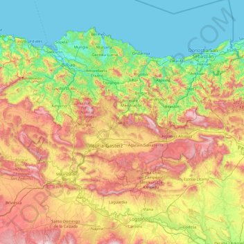
Name: Autonomous Community of the Basque Country topographic map, elevation, terrain.
Location: Autonomous Community of the Basque Country, Spain (42.47134 -3.45091 43.45686 -1.72927)
Average elevation: 454 m
Minimum elevation: -2 m
Maximum elevation: 1,471 m
The topography of the Basque Country is mainly mountainous. It is made up of the Basque Mountains and the Sierra de Cantabria in the south, with Larrasa (1453 meters) as the maximum altitude. The highest point in the Community is Mount Aitxuri, with an altitude of 1,551 meters, and located in Aizkorri Natural Park.
Other topographic maps
Click on a map to view its topography, its elevation and its terrain.
Casas del Lomo
Casas del Lomo, Tejeda, Las Palmas, Canary Islands, 35360, Spain
Average elevation: 1,226 m
Iznate
Spain > Andalusia > La Axarquía
Iznate, La Axarquía, Malaga, Andalusia, 29792, Spain
Average elevation: 251 m
Granada
Spain > Andalusia > Comarca de la Vega de Granada
Granada, Comarca de la Vega de Granada, Granada, Andalusia, Spain
Average elevation: 829 m
Cornudella de Montsant
Cornudella de Montsant, Priorat, Tarragona, Catalonia, 43360, Spain
Average elevation: 700 m
Panticosa
Spain > Aragon > Alto Gállego
Panticosa, Alto Gállego, Huesca, Aragon, Spain
Average elevation: 1,916 m
Málaga
Spain > Andalusia > Málaga-Costa del Sol
Málaga, Málaga-Costa del Sol, Malaga, Andalusia, Spain
Average elevation: 276 m
Barcelona
Spain > Catalonia > Barcelonès
Barcelona, Barcelonès, Barcelona, Catalonia, 08001, Spain
Average elevation: 65 m
Veleta
Spain > Castile and León > Valle del Retortillo
Veleta, Valle del Retortillo, Palencia, Castile and León, 34307, Spain
Average elevation: 791 m
Campell
Spain > Valencian Community > Pedreguer
Campell, Pedreguer, la Marina Alta, Alacant / Alicante, Valencian Community, 03750, Spain
Average elevation: 115 m
Ronda
Spain > Andalusia > Serranía de Ronda
Ronda, Serranía de Ronda, Malaga, Andalusia, Spain
Average elevation: 801 m
Alicante
Alicante, l'Alacantí, Alacant / Alicante, Valencian Community, Spain
Average elevation: 143 m
Trillo
Trillo, Guadalajara, Castile-La Mancha, 19450, Spain
Average elevation: 899 m
Sant Martí
Spain > Catalonia > Barcelonès > Barcelona
Sant Martí, Barcelona, Barcelonès, Barcelona, Catalonia, 08001, Spain
Average elevation: 17 m
Hospital
Spain > Galicia > Os Ancares > Pedrafita do Cebreiro
Hospital, Pedrafita do Cebreiro, Os Ancares, Lugo, Galicia, Spain
Average elevation: 1,184 m
Aldeatejada
Aldeatejada, Salamanca, Castile and León, Spain
Average elevation: 838 m
Vitales
Spain > Aragon > Hoya de Huesca / Plana de Uesca > Monflorite-Lascasas
Vitales, Monflorite-Lascasas, Hoya de Huesca / Plana de Uesca, Aragon, 22112, Spain
Average elevation: 492 m
Navajas
Navajas, l'Alt Palància, Castelló / Castellón, Valencian Community, 12470, Spain
Average elevation: 441 m
la Coma
Spain > Catalonia > Solsonès > la Coma i la Pedra
la Coma, la Coma i la Pedra, Solsonès, Lleida, Catalonia, 25284, Spain
Average elevation: 1,308 m
Benifato
Benifato, la Marina Baixa, Alacant / Alicante, Valencian Community, Spain
Average elevation: 939 m
Barbadillo de Herreros
Barbadillo de Herreros, Burgos, Castile and León, 09615, Spain
Average elevation: 1,448 m
Santa Cruz de la Zarza
Santa Cruz de la Zarza, Toledo, Castile-La Mancha, 45370, Spain
Average elevation: 724 m
Blanca
Spain > Castile and León > Riello
Blanca, Riello, León, Castile and León, 24127, Spain
Average elevation: 1,193 m
La Unión de los Tres Ejércitos
La Unión de los Tres Ejércitos, Clavijo, Rioja, 26141, Spain
Average elevation: 650 m