
Tolva topographic map
Click on the map to display elevation.
About this map
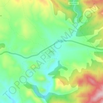
Name: Tolva topographic map, elevation, terrain.
Location: Tolva, Ribagorza, Huesca, Aragon, 22585, Spain (42.09494 0.54508 42.13494 0.58508)
Average elevation: 739 m
Minimum elevation: 614 m
Maximum elevation: 952 m
Other topographic maps
Click on a map to view its topography, its elevation and its terrain.
Zaragoza
On 1 January 2019 the population of the city of Zaragoza was 706,904, within its administrative limits on a land area of 1,062.64 square kilometres (410.29 square miles), ranking fifth in Spain. It is the 32nd most populous municipality in the European Union. The population of the metropolitan area was…
Average elevation: 701 m
Manzanera
Spain > Aragon > Gúdar-Javalambre
Manzanera is a settlement located in the South of Aragon, at an altitude of 960 m (3,150 ft) above sea level in the Sierra de Javalambra, where the tallest point of the province is located as well as one of the tallest of the Iberian System, near the Province of Castellón. It enjoys a continental…
Average elevation: 1,224 m
Zaragoza
On 1 January 2021, the population of the municipality of Zaragoza was 675,301, (as of 2023, the fourth or fifth most populous in Spain) on a land area of 973.78 square kilometres (375.98 square miles). It is the 26th most populous municipality in the European Union. The population of the metropolitan area was…
Average elevation: 361 m
Daroca
Spain > Aragon > Campo de Daroca
The climate in Daroca is cold semi-arid (BSk) bordering on a humid subtropical climate (Cfa) under the Köppen classification. It has an oceanic with hot summer and cool winter (Doak) under the Trewartha classification. This type of climate is common in inland Spain, with low annual rainfall and high summer…
Average elevation: 866 m
Jaca
Jaca has a submediterranean climate (Köppen: Cfb) bordering a submediterranean climate (Köppen: Cfa) with strong continental influences caused by the city's high altitude of 820 metres (2,690 ft). Winters are cool and summers are warm, with hot daytime temperatures but relatively cool nights. There isn't any…
Average elevation: 1,223 m
Zaragoza
On 1 January 2021, the population of the municipality of Zaragoza was 675,301, (as of 2023, the fourth or fifth most populous in Spain) on a land area of 973.78 square kilometres (375.98 square miles). It is the 26th most populous municipality in the European Union. The population of the metropolitan area was…
Average elevation: 361 m
Los Monegros
The Sierra de Alcubierre mountain chain crosses the comarca from Northwest to Southeast. Its maximum elevation is 822 meters, at the mountain called Oscuro. The climate is semiarid, with scarce rainfall and high temperatures in the autumn. The area has numerous saltwater and freshwater lakes, including the…
Average elevation: 351 m
Almudévar
Spain > Aragon > Hoya de Huesca / Plana de Uesca
The relief of the municipality is predominantly flat, and includes part of the Llanos de la Violada. The altitude oscillates between 603 meters north (Saso Plano) and 390 meters south. The town is 456 m above sea level.
Average elevation: 429 m
Jaca
Jaca has an submediterranean climate (Köppen: Cfb) bordering a submediterranean climate (Köppen: Cfa) with strong continental influences caused by the city's high altitude of 820 metres (2,690 ft). Winters are cool and summers are warm, with hot daytime temperatures but relatively cool nights. There isn't…
Average elevation: 1,223 m
Valdelinares
Spain > Aragon > Gúdar-Javalambre
The elevation of the village is 1,690 metres (5,540 ft) above sea level, making this town the highest in Peninsular Spain among those which are the seat of a municipality.
Average elevation: 1,723 m
Puertomingalvo
Spain > Aragon > Gúdar-Javalambre
Puertomingalvo is a municipality located at high elevation in the province of Teruel, Aragon, Spain. According to the 2004 census (INE), the municipality has a population of 182 inhabitants.
Average elevation: 1,387 m
Jaca
Jaca has a submediterranean climate (Köppen: Cfb) bordering a submediterranean climate (Köppen: Cfa) with strong continental influences caused by the city's high altitude of 820 metres (2,690 ft). Winters are cool and summers are warm, with hot daytime temperatures but relatively cool nights. There isn't any…
Average elevation: 1,223 m