
Make a donation
Gear up for your next adventure:
As an Amazon Associate, this site earns from qualifying purchases at no extra cost to you.
Fenwick Hills topographic map
Click on the map to display elevation.
Make a donation
Gear up for your next adventure:
As an Amazon Associate, this site earns from qualifying purchases at no extra cost to you.
About this map
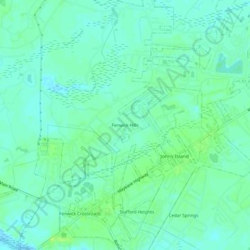
Name: Fenwick Hills topographic map, elevation, terrain.
Average elevation: 6 m
Minimum elevation: -3 m
Maximum elevation: 14 m
Make a donation
Gear up for your next adventure:
As an Amazon Associate, this site earns from qualifying purchases at no extra cost to you.
Other topographic maps
Click on a map to view its topography, its elevation and its terrain.
Charleston
United States > South Carolina > Charleston County
Charleston is characterized by its relatively flat topography, with an average elevation of about 10 feet above sea level, making it prone to flooding during heavy rains and storms. The city is situated on a peninsula bordered by the Ashley River to the west and the Cooper River to the east, creating a natural…
Average elevation: 4 m
Kiawah Island
United States > South Carolina > Charleston County
Kiawah Island features a low-lying, sandy topography typical of barrier islands along the southeastern coast of the United States. The island's average elevation is about 10 feet above sea level, with some areas reaching slightly higher. Its terrain is characterized by broad, flat beaches that gently slope…
Average elevation: 2 m
Make a donation
Gear up for your next adventure:
As an Amazon Associate, this site earns from qualifying purchases at no extra cost to you.
Francis Marion National Forest
United States > South Carolina > Charleston County
Average elevation: 5 m
Make a donation
Gear up for your next adventure:
As an Amazon Associate, this site earns from qualifying purchases at no extra cost to you.
Make a donation
Gear up for your next adventure:
As an Amazon Associate, this site earns from qualifying purchases at no extra cost to you.
Hoopstick Island
United States > South Carolina > Charleston County > Johns Island
Average elevation: 4 m
Make a donation
Gear up for your next adventure:
As an Amazon Associate, this site earns from qualifying purchases at no extra cost to you.
North Charleston Wannamaker County Park
United States > South Carolina > Charleston County > North Charleston
Average elevation: 8 m
Make a donation
Gear up for your next adventure:
As an Amazon Associate, this site earns from qualifying purchases at no extra cost to you.
Hamlin Sound
United States > South Carolina > Charleston County > Mount Pleasant
Average elevation: 1 m
Make a donation
Gear up for your next adventure:
As an Amazon Associate, this site earns from qualifying purchases at no extra cost to you.
Forest Park
United States > South Carolina > Charleston County > Charleston > Maryville
Average elevation: 5 m
Make a donation
Gear up for your next adventure:
As an Amazon Associate, this site earns from qualifying purchases at no extra cost to you.
Make a donation
Gear up for your next adventure:
As an Amazon Associate, this site earns from qualifying purchases at no extra cost to you.
Make a donation
Gear up for your next adventure:
As an Amazon Associate, this site earns from qualifying purchases at no extra cost to you.