
Mount Pleasant topographic map
Click on the map to display elevation.
Mount Pleasant
Mount Pleasant occupies a very low, gently undulating Lowcountry setting on the South Carolina Coastal Plain, where the town spreads across interfluves and former island-like uplands between the Cooper River, the Wando River, Charleston Harbor, Shem Creek, tidal creeks, and the Intracoastal Waterway. Its relief is subdued, with most built-up areas lying only a few feet to a few tens of feet above sea level, while the slightly higher inland ridges and neighborhood plateaus rise modestly above surrounding marshes and drainage corridors. The broader Charleston area is described as a drowned coastal-plain landscape with dendritic tidal drainage, this explains Mount Pleasant’s strongly water-shaped terrain, where broad salt marshes, creek valleys, low bluffs, filled or modified waterfronts, and sandy barrier-island margins toward Sullivan’s Island and Isle of Palms define the physical character of the landscape. Overall, the topography is flat to gently rolling, open, estuarine, and flood-prone, with elevation contrasts expressed less as hills than as subtle transitions from marsh and tidal flats to slightly raised coastal terraces and developed uplands.
About this map
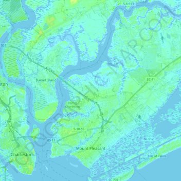
Name: Mount Pleasant topographic map, elevation, terrain.
Average elevation: 3 m
Minimum elevation: -4 m
Maximum elevation: 19 m
Other topographic maps
Click on a map to view its topography, its elevation and its terrain.
Hobcaw Point
United States > South Carolina > Charleston County > Mount Pleasant
Average elevation: 4 m
Saint Andrews Heights
United States > South Carolina > Charleston County > Charleston
Average elevation: 5 m
Pinewood Vista
United States > South Carolina > Charleston County > North Charleston
Average elevation: 9 m
Palmetto Fort
United States > South Carolina > Charleston County > Mount Pleasant
Average elevation: 4 m
Fenwick Crossroads
United States > South Carolina > Charleston County > Charleston
Average elevation: 5 m
Jamestown Estates
United States > South Carolina > Charleston County > James Island
Average elevation: 4 m
Brook Green Meadow
United States > South Carolina > Charleston County > Mount Pleasant
Average elevation: 4 m
Remleys Point
United States > South Carolina > Charleston County > Mount Pleasant
Average elevation: 4 m
Camp Saint Christopher
United States > South Carolina > Charleston County > Seabrook Island
Average elevation: 2 m
North Charleston Wannamaker County Park
United States > South Carolina > Charleston County > North Charleston
Average elevation: 8 m
Forest Park
United States > South Carolina > Charleston County > Charleston > Maryville
Average elevation: 5 m
Liberty Hill
United States > South Carolina > Charleston County > North Charleston
Average elevation: 7 m
Wando Estates
United States > South Carolina > Charleston County > Mount Pleasant
Average elevation: 5 m
Forest Trail
United States > South Carolina > Charleston County > Isle of Palms
Average elevation: 1 m
Saint Andrews Heights
United States > South Carolina > Charleston County > Charleston
Average elevation: 5 m
Ashley Junction
United States > South Carolina > Charleston County > North Charleston
Average elevation: 7 m
Camp Saint Christopher
United States > South Carolina > Charleston County > Seabrook Island
Average elevation: 2 m
North Charleston
United States > South Carolina > Charleston County > North Charleston
Average elevation: 5 m
Northwood Estates
United States > South Carolina > Charleston County > North Charleston > Northwood Estates
Average elevation: 8 m
Country Club Estates
United States > South Carolina > Charleston County > Charleston
Average elevation: 3 m
Deerwood Heights
United States > South Carolina > Charleston County > North Charleston
Average elevation: 8 m