
Bener Meriah topographic map
Interactive map
Click on the map to display elevation.
About this map
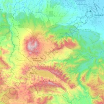
Name: Bener Meriah topographic map, elevation, terrain.
Location: Bener Meriah, Aceh, Sumatra, Indonesia (4.57760 96.57593 4.97020 97.32872)
Average elevation: 795 m
Minimum elevation: -1 m
Maximum elevation: 2,846 m
Other topographic maps
Click on a map to view its topography, its elevation and its terrain.
Lhokseumawe
Lhokseumawe City is located between 4˚ - 5˚ North Latitude and 96˚ - 97˚ East Longitude with an average altitude of 13 metres above sea level. Lhokseumawe was given the status of an independent city (separate from North Aceh Regency, which surrounds it on all the landward sides) based on Law Number 2 of…
Average elevation: 29 m