
Kaikōura topographic map
Interactive map
Click on the map to display elevation.
Kaikōura
The Hutton's shearwater (Puffinus huttoni) or Kaikōura tītī is an endangered seabird in the family Procellariidae. It is found in waters around Australia and New Zealand but it only breeds in the Seaward Kaikōura Range in New Zealand. It is the only seabird in the world that breeds in an alpine environment. Nests have been found at elevations from 1200 to 1800 metres. The Kowhai Valley and Shearwater Stream Important Bird Area contains the only two remaining alpine breeding colonies. An artificial colony was established in a protected area on the Kaikōura peninsula as a conservation measure, after six other colonies were wiped out by feral pigs. The birds fly at night, but can become disoriented by bright lights. Fledglings are particularly vulnerable, and can crash-land on roads in the town. They are usually unable to take off again, making them vulnerable to being run over by vehicles or succumbing to predation by dogs or cats. Conservation organizations in Kaikōura rescue stranded birds for later release, and advocate for reduced lighting.
About this map
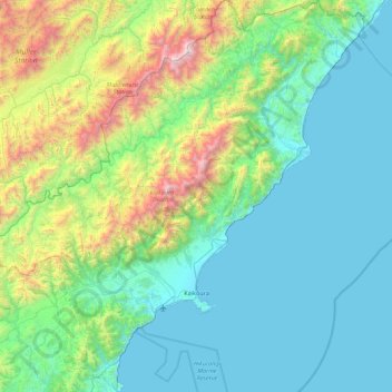
Name: Kaikōura topographic map, elevation, terrain.
Location: Kaikōura, Canterbury, New Zealand (-42.56573 173.18065 -41.90740 174.06338)
Average elevation: 530 m
Minimum elevation: 0 m
Maximum elevation: 2,849 m
Other topographic maps
Click on a map to view its topography, its elevation and its terrain.
Lake Ōhau
New Zealand > Canterbury > Waitaki District
Wilding Pines (Pinus Cortorta, Pinus sylvestris) are problematic on the foreshore of Lake Ōhau. Pinus contorta grow “probably five to 10 times faster” in the Mackenzie Country (and Lake Ōhau) than in their native North America. They can establish themselves at altitudes of up to 2000 metres. Where they…
Average elevation: 904 m
Methven
New Zealand > Canterbury > Ashburton District
Methven (Māori: Piwakawaka) is a small town in the Canterbury region of the South Island of New Zealand. It is located near the western edge of the Canterbury Plains, 35 km (22 mi) north of Ashburton and 95 km (59 mi) west of Christchurch, and at an elevation of 320 m (1,050 ft). The town is a service centre…
Average elevation: 322 m
Hanmer Springs
New Zealand > Canterbury > Hurunui District
The Jacks Pass – Clarence River – Jollies Pass Loop is a 25 kilometres (16 mi) loop which is not technically challenging; however, it takes between two and four hours to complete. It can be ridden in either direction: West over Jacks Pass (869 m) or East over Jollies Pass (850 m). As the entire ride is at…
Average elevation: 490 m
Un named plug
New Zealand > Canterbury > Christchurch City > Banks Peninsula Community > Diamond Harbour
Average elevation: 164 m
Lake Tekapo
New Zealand > Canterbury > Mackenzie District
Lake Tekapo (Māori: Takapō) is the second-largest of three roughly parallel lakes running north–south along the northern edge of the Mackenzie Basin in the South Island of New Zealand (the others are Lake Pukaki and Lake Ōhau). It covers an area of 83 square kilometres (32 sq mi) and is at an altitude of…
Average elevation: 1,025 m
Akaroa
New Zealand > Canterbury > Christchurch City > Banks Peninsula Community
Average elevation: 191 m
Barrys Bay
New Zealand > Canterbury > Christchurch City > Banks Peninsula Community
Average elevation: 100 m
Haytor
New Zealand > Canterbury > Christchurch City > Banks Peninsula Community
Average elevation: 348 m
Mount Cook
New Zealand > Canterbury > Mackenzie District
Temperatures at the mountain's base in the Hooker Valley around 800 metres (2,600 feet) range from −13 °C (9 °F) to 32 °C (90 °F), and generally fall just over 1 °C for every 200 metres of altitude.
Average elevation: 2,920 m
Styx Mill Conservation Reserve
New Zealand > Canterbury > Christchurch City > Christchurch
Average elevation: 14 m
New Brighton Beach
New Zealand > Canterbury > Christchurch City > Coastal-Burwood Community
Average elevation: 4 m
Queen Elizabeth II Park
New Zealand > Canterbury > Christchurch City > Coastal-Burwood Community
Average elevation: 4 m
Linwood-Central-Heathcote Community
New Zealand > Canterbury > Christchurch City
Average elevation: 55 m
Brasenose
New Zealand > Canterbury > Christchurch City > Banks Peninsula Community
Average elevation: 483 m
Arthur's Pass
New Zealand > Canterbury > Selwyn District
Arthur's Pass township is about 5 kilometres (3.1 mi) south of the mountain pass with the same name. Its elevation is 740 metres (2,430 ft) above sea level surrounded by beech forest. The Bealey River runs through the township. The town is located 153 kilometres (95 mi) from Christchurch a 2-hour drive on…
Average elevation: 1,204 m
Halswell-Hornby-Riccarton Community
New Zealand > Canterbury > Christchurch City
Average elevation: 49 m
Fairlie
New Zealand > Canterbury > Mackenzie District
Fairlie is a Mackenzie District service town (or township) located in the Canterbury region of the South Island of New Zealand. The estimated population was 930 as of June 2022. Being on state highway 8 between Christchurch (182 km, 2 hours 20 minutes drive) and Queenstown (300 km 3.5 hours drive), tourism is…
Average elevation: 317 m