
金沢城公園 topographic map
Interactive map
Click on the map to display elevation.
About this map
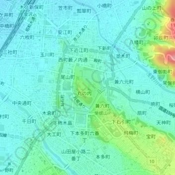
Name: 金沢城公園 topographic map, elevation, terrain.
Location: 金沢城公園, 金沢市, 石川県, 中部地方, 日本 (36.56230 136.65639 36.56907 136.66255)
Average elevation: 30 m
Minimum elevation: 8 m
Maximum elevation: 118 m
Other topographic maps
Click on a map to view its topography, its elevation and its terrain.