
Evolène topographic map
Interactive map
Click on the map to display elevation.
About this map
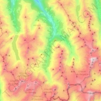
Name: Evolène topographic map, elevation, terrain.
Location: Evolène, Ering, Wallis, 1983, Schweiz (45.95490 7.42553 46.14706 7.61195)
Average elevation: 2,697 m
Minimum elevation: 1,129 m
Maximum elevation: 4,350 m
Für die Normalperiode 1991–2020 beträgt die Jahresmitteltemperatur 4,5 °C, wobei im Februar mit −2,8 °C die kältesten und im Juli mit 12,7 °C die wärmsten Monatsmitteltemperaturen gemessen werden. Im Mittel sind hier rund 159 Frosttage und 50 Eistage zu erwarten. Sommertage gibt es im Durchschnitt 1,8. Die Messstation von MeteoSchweiz liegt auf einer Höhe von 1825 m ü. M. an Südhang nahe dem Dorf Villa, ca. 450 m höher gelegen als der Dorfkern von Evolène.
Other topographic maps
Click on a map to view its topography, its elevation and its terrain.
Pigne d'Arolla
Schweiz > Wallis > Ering > Evolène
Pigne d'Arolla, Evolène, Ering, Wallis, 1983, Schweiz
Average elevation: 3,280 m
Eison (St-Martin)
Schweiz > Wallis > Ering > Saint-Martin (VS)
Eison (St-Martin), Saint-Martin (VS), Ering, Wallis, 1969, Schweiz
Average elevation: 1,761 m
Suen (St-Martin)
Schweiz > Wallis > Ering > Saint-Martin (VS)
Suen (St-Martin), Saint-Martin (VS), Ering, Wallis, 1969, Schweiz
Average elevation: 1,314 m
Mase
Schweiz > Wallis > Ering > Mont-Noble
Mase, Mont-Noble, Ering, Wallis, 1968, Schweiz
Average elevation: 1,272 m
Les Prasses
Schweiz > Wallis > Ering > Vex > Les Prasses
Les Prasses, Vex, Ering, Wallis, 2305, Schweiz
Average elevation: 1,039 m
Nax
Schweiz > Wallis > Ering > Mont-Noble
Nax, Mont-Noble, Ering, Wallis, 1973, Schweiz
Average elevation: 990 m