
Neamț topographic map
Interactive map
Click on the map to display elevation.
About this map
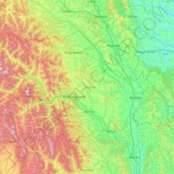
Name: Neamț topographic map, elevation, terrain.
Location: Neamț, Romania (46.64171 25.65959 47.34032 27.24365)
Average elevation: 512 m
Minimum elevation: 48 m
Maximum elevation: 1,826 m
Other topographic maps
Click on a map to view its topography, its elevation and its terrain.
Dorolea
Dorolea, Livezile, Bistrița-Năsăud, 427122, Romania
Average elevation: 488 m
Dealul cu Drum
Dealul cu Drum, Greci, Tulcea, 827080, Romania
Average elevation: 168 m
Carpathian Mountains
Carpathian Mountains, Toplița, Harghita, 535705, Romania
Average elevation: 980 m