
Lanzhou New Area topographic map
Interactive map
Click on the map to display elevation.
About this map
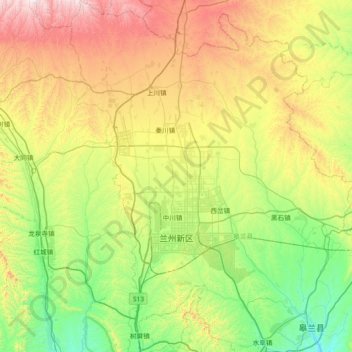
Name: Lanzhou New Area topographic map, elevation, terrain.
Location: Lanzhou New Area, Lanzhou, Gansu, China (36.28722 103.44659 36.87489 103.91035)
Average elevation: 2,034 m
Minimum elevation: 1,607 m
Maximum elevation: 2,878 m
Lanzhou's main urban area is constrained in size by its geographical topography, since it is a typical valley sandwiched by mountains, with the Yellow River crossing by. The topography of Lanzhou hampers this city to become a continuous megacity like Beijing or Xi’an. The General Office of the State Council issued the Several Advice about Supporting the Development of Economy and Society of Gansu Province in May 2010, especially stating that Lanzhou has to be the impetus of the development of Gansu Province, and even the whole northwestern region. Not long after, on August 3, 2010, the Lanzhou Municipal Government, by the 7th Session of the 11th convention of Lanzhou Municipal Council, announced the strategy of building a new city in Qinwangchuan plain, which now called Lanzhou New Area. Later, the Gansu Provincial Government issued the Consulting Advice about Promoting Constructions in Lanzhou New Area in order to support the development of LNA.
Other topographic maps
Click on a map to view its topography, its elevation and its terrain.
Sangyuanli
China > Gansu > Kang County
Sangyuanli, Kang County, Longnan, Gansu, China
Average elevation: 1,480 m
Gaojiazhuang
Gaojiazhuang, Zaojiao, Qinzhou District, Tianshui, Gansu, China
Average elevation: 1,590 m
Manwan
China > Gansu > Huining County > Dingjiagou
Manwan, Dingjiagou, Huining County, Baiyin City, Gansu, China
Average elevation: 2,216 m
Chenzui
China > Gansu > Jingning County > Leida
Chenzui, Leida, Jingning County, Pingliang City, Gansu, China
Average elevation: 1,780 m
Maqu County
Maqu County, Gannan Tibetan Autonomous Prefecture, Gansu, China
Average elevation: 3,812 m
Têwo County
Têwo County, Gannan Tibetan Autonomous Prefecture, Gansu, China
Average elevation: 3,194 m
Yumen
China > Gansu > Yumen City > Yumen > Xinshiqu Subdistrict
Yumen, Xinshiqu Subdistrict, Yumen City, Jiuquan, Gansu, 735200, China
Average elevation: 1,510 m
Dingxi
China > Gansu > Dingxi > Zhonghualu Subdistrict
Dingxi, Zhonghualu Subdistrict, Anding District, Dingxi City, Gansu, China
Average elevation: 2,040 m
Linxia
China > Gansu > Linxia County > Linxia
Linxia, Linxia County, Linxia Hui Autonomous Prefecture, Gansu, China
Average elevation: 2,347 m
Jinchang
China > Gansu > Jinchang > Xinhualu Subdistrict
Jinchang, Xinhualu Subdistrict, Jinchuan District, Jinchang, Gansu, 737100, China
Average elevation: 1,669 m
Zhangye Danxia National Geological Park
China > Gansu > Linze County > Nantai
Zhangye Danxia National Geological Park, Nantai, Linze County, Zhangye, Gansu, 734200, China
Average elevation: 1,759 m
Qulong
China > Gansu > Têwo County > Qulong
Qulong, Têwo County, Gannan Tibetan Autonomous Prefecture, Gansu, China
Average elevation: 3,195 m
Kang County
China > Gansu > Kang County > Kang County
Kang County, Longnan City, Gansu, China
Average elevation: 1,468 m
Jiuquan
China > Gansu > Xincheng Subdistrict
Jiuquan, Xincheng Subdistrict, Suzhou District, Jiuquan, Gansu, 735000, China
Average elevation: 1,543 m
Xizang
China > Gansu > Zhugqu County
Xizang, Zhugqu County, Gannan Tibetan Autonomous Prefecture, Gansu, 746300, China
Average elevation: 2,398 m
Gannan
China > Gansu > Hezuo City > Tongqin
Gannan, Tongqin, Hezuo City, Gannan Tibetan Autonomous Prefecture, Gansu, 747000, China
Average elevation: 3,075 m
Zhouqu County
Zhouqu County, Gannan Tibetan Autonomous Prefecture, Gansu, 746300, China
Average elevation: 2,633 m
Tianshui
China > Gansu > Xiguan Subdistrict
Tianshui, Xiguan Subdistrict, Qinzhou District, Tianshui, Gansu, China
Average elevation: 1,458 m
Zhangye
China > Gansu > Beijie Subdistrict
Zhangye, Beijie Subdistrict, Ganzhou District, Zhangye, Gansu, 734000, China
Average elevation: 1,531 m